
Primary outflows Belews Creek Surface area 3,864-acre (16 km) | Primary inflows Area 15.64 km² | |
 | ||
Location | ||
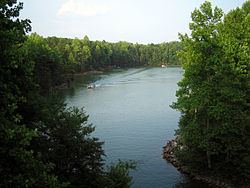
Belews Lake is a reservoir in Stokes, Rockingham, Guilford and Forsyth counties of North Carolina, near the towns of Stokesdale and Pine Hall. It was created in 1973 by the Duke Energy corporation to provide cooling water for the corporation's Belews Creek Steam Station, a coal-burning power plant.
Contents
Map of Belews Lake, North Carolina, USA
The lake has a surface area of 3,864 acres (16 km2) and an 88-mile (142 km) shoreline. It is held back by a rolled earth dam and a concrete spillway. The northern portion of the lake commonly has depths of over 100 feet (30 m) and the lake reaches up to 130 feet (40 m) deep in the vicinity of the dam. There is no hydroelectric power generation at this dam, so the lake is not bound by many FERC regulations.
It was formed from Belews Creek, a small tributary of the Dan River. U.S. Route 158 and North Carolina Highway 65, as well as a number of secondary roads provide access to the lake. Boating and water skiing are common on the lake.
Two marinas on the lake include Humphrey's Ridge, which has a grill that serves food, and Carolina Marina, which has boat sales and service facilities.