
Population (2015) 467 | Council Har Hebron Founded 1979 | |
 | ||
Weather 10°C, Wind W at 18 km/h, 92% Humidity | ||
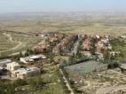
Beit Yatir (Hebrew: בית יתיר), also known as Metzadot Yehuda (Hebrew: מְצָדוֹת יְהוּדָה), is a religious Orthodox moshav and Israeli settlement in the southern Hebron Hills of the West Bank. Located on a hill 900 metres above sea level near the Green Line south of Susiya and close to the Palestinian village of as-Seefer, it falls under the jurisdiction of Har Hebron Regional Council. In 2015 it had a population of 467.
Contents
Map of Metsadot Yehuda
The ruins of the ancient town of Eshtemoa are nearby.
The international community considers Israeli settlements in the West Bank illegal under international law, but the Israeli government disputes this.
History
Beit Yatir was established in 1979 by students from the Mercaz HaRav Yeshiva. In 1983, the moshav was moved southwest from its original location south of the town of as-Samu to its current location in the Yatir Forest. A visual landmark of the moshav is a high wind turbine.
The social make up of the moshav residents varies between sabras to immigrants from various countries including France, Russian, Brazil and English-speaking countries. The moshav does not require residents to become members of the cooperative.
Education
A Religious Pre-Army Mechina, with several dozen students enrolled, is headed by Rabbi Moshe Hagar.