
Time zone EET (UTC+2) Elevation 800 m | Dialing code +961-4- Local time Thursday 3:31 AM | |
 | ||
Weather 14°C, Wind SW at 21 km/h, 78% Humidity | ||
Lebanon beit mery ruins interactive
Beit Mery (Arabic: بيت مري) is a Lebanese town overlooking the capital Beirut. The town has been a summer mountain resort since the times of the Phoenicians and later the Romans. The name derives from Aramaic and means "The house of my Lord". On one of the three hills of Beit Mery (Southern end of town) along the Lebanon Western mountain range are the ruins of the old Phoenician and Roman temples that were erected in the same general area in what is now known as Deir El-Qala'a (دير القلعة). At present, a Christian church and monastery sit on top of parts of the old Roman temple. Beit Mery is home to a Lebanese Red Cross First Aid Center.
Contents
- Lebanon beit mery ruins interactive
- Map of Beit Meri Lebanon
- For sale a luxurious villa in beit mery lebanon lb00014
- Culture
- Demography
- Geography
- History
- Archaeology
- Tourism
- References
Map of Beit Meri, Lebanon
For sale a luxurious villa in beit mery lebanon lb00014
Culture
In winter, the town is also the scene of an annual cultural festival, the Al Bustan festival, held in the theatre of the Al Bustan hotel, which features international drama and dance groups as well as orchestras and chamber ensembles. The festival was created in 1994 by Myrna Al Bustani, owner of the hotel, and since then has been one of the major cultural landmarks of the winter season.
Among the artists who performed at the festival, Julian Lloyd Webber (cellist), Gautier Capuçon (cellist), Gianluca Marciano (conductor), Virginia Tola (soprano), Inva Mula (soprano), Helikon Opera, Stile Antico, Evelyn Glennie (percussions), Boris Berezovsky (pianist), Khatia Buniatishvili (pianist), Alondra de la Parra (conductor), Oliver Poole (pianist), Anna Tifu (violin).
Demography
The residents of Beit Mery are mainly Christian (Maronite, Greek Orthodox, Greek Catholic, Armenian Orthodox) and Druze.
Geography
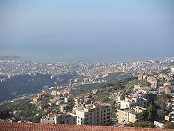
Beit Mery occupies a hill, 700–750 meters above sea level, which gives the picturesque town spectacular views of the Beirut peninsula and part of Lebanon's Mediterranean coast.And has an area of 5.48 km2. Since 2000 Beit Mery started to be a suburban town and is 16 km away from Beirut.
History
The Roman rulers of Lebanon made Beit Mery their summer resort due to its high location and pleasant summer weather.
Archaeology
There are two prehistoric archaeological sites in Beit Meri where flint industries have been found by Jesuit archaeologists.
Beit Mery I is on the right bank of the Beirut River, south southwest of the town at an altitude of approximately 125 metres (410 ft) above sea level. It was found by Jesuit Father Dillenseger who determined it to be an Acheulean site. The material was donated to the Saint Joseph University by the French Faculty of Medicine.
Beit Mery II is east of the road from Beit Mery to Deir el Qala'a on a sloping plateau facing the junction of the Nahr Meten and Nahr Jamani. It was found by M. Gautier who recovered Heavy Neolithic flint tools from the surface. V. Hankey also recovered some retouched blades from this area.
Tourism
The town is known for its ancient Roman and Byzantine ruins as well as the historic Maronite Monastery of Saint John the Baptist, ( Deir el Kalaa) which was built in 1750. The town, which is only 16 km from Beirut, continues to be a major summer resort in Lebanon with a famous landmark hotel, the Al Bustan. Lush pine forests surround the town. Restaurants with panoramic views of the valleys and the sea make Beit Mery a favorite summer spot.