
Mouth elevation 0 | ||
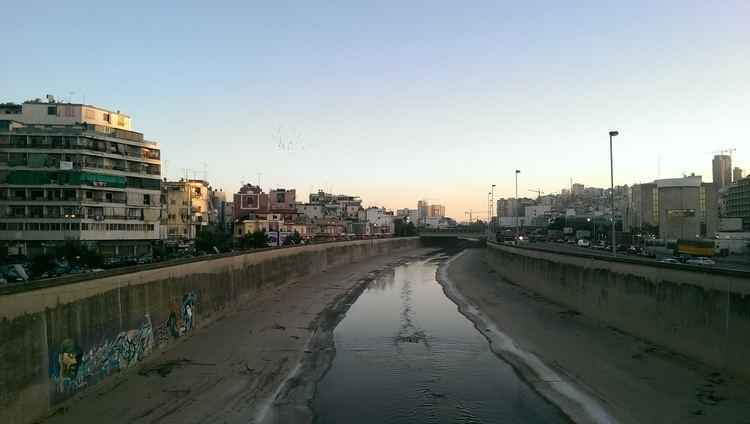 | ||
Lebanon s beirut river mysteriously turns blood red bible prophecy feb 16 2012
Beirut River (Arabic: نهر بيروت, Nahr Bayrūt) is a river in Lebanon. The river runs east to west, then curves north, separating the city of Beirut from its eastern suburbs, primarily Bourj Hammoud and Sin el Fil. According to popular legend, St. George slew the dragon in a spot near the mouth of the river.
Contents
- Lebanon s beirut river mysteriously turns blood red bible prophecy feb 16 2012
- Map of Beirut River Lebanon
- Stone Age
- Antiquity
- Renaissance
- Industrial Age
- Beirut River Valley
- Urban Sprawl
- Flood Risks
- Rehabilitation of the River
- Bridges
- References
Map of Beirut River, Lebanon
Stone Age
During the Stone Age, Beirut was two islands in the delta of the Beirut River, but over the centuries, the river silted up, and the two islands were connected into one land mass. The right bank of the Beirut River, southwest of the mountain resort town of Beit Mery at an altitude of approximately 125 metres (410 ft) above sea level is an archeological site, "Beit Mery I," that was found by Jesuit Father Dillenseger who determined it to be an Acheulean site; the archaeological finds from the site were donated to the French Faculty of Medicine at the Saint Joseph University.
Antiquity
In antiquity, the river was known as Magoras, and it was the site of the worship of the god of Heliopolis. The Romans built an aqueduct, which had a 240-meter bridge crossing the river, to supply Beirut (Berytus) with water.
Renaissance
It is believed that Fakhreddine, Lebanon's Renaissance prince, built or repaired a bridge of seven arches on the river that was a streamlet in summer but swelled into a raging torrent in winter.
Industrial Age
In the Industrial Age, the banks of the river, which had been marshy lands that flooded each winter season, especially in Bourj Hammoud, became home to warehouses and shipping services due to the close proximity of the river to the port. By the mid-1800s, Beirut had expanded to within 10 kilometers of the river, which continued to supply the city with water via the Roman aqueduct.
Beirut River Valley
According to environmentalists, the 20-kilometer valley of the Beirut River, especially the upper valley, is one of the most important areas for bird migration in Lebanon, including birds of 33 different species, such as the European Honey-buzzard, Levant Sparrowhawk Accipiter brevipes, Common Buzzard Buteo buteo, White Stork, White Pelican, European Nightjar Caprimulgus europaeus, European Bee-eater Merops a piaster, Barn Swallow Hirundo rustica and the Lesser Spotted Eagle.
Urban Sprawl
The river valley stretches across several municipalities that do not formally protect it from hunting, fire, urban development, deforestation, water pollution and overgrazing. Once the river reaches the city limits of the Greater Beirut metropolitan area, it becomes polluted with the major source of pollution being industrial waste from various factories along the bank as well as sewage and refuse from the slaughterhouse in Karantina. In 2004, Cedar Environmental built a composter, aiming to prevent the slaughterhouse from directly dumping waste into the Beirut River.
Flood Risks
The river was transformed from a riparian river to a concrete canal in 1968. In 1970, extensive work was done along the river bank to protect the eastern suburb of Bourj Hammoud from floods. In 1974, ETEC Consulting Engineers were hired to design a flood control system that included a channel 32 meters wide, with capacity of 800 m3/s.
Environmentalists warned in 2003 that some construction companies were dumping illegally in the river that prompted the passing of Law 148 which stipulated that all construction projects should be located at least 500 meters away from the main rivers in Lebanon.
In 2005, storms caused flood damage in the suburbs of Bourj Hammoud and Karantina, and a bridge adjacent to the Port of Beiurt collapsed due to water pressure. In 2005, the City of Bourj Hammoud in conjunction with CETE Méditerranée with logistical support from the City of Marseille, initiated a risks diagnosis that revealed seismic, flood and technological risks for the suburb.
Rehabilitation of the River
There is great interest among Lebanese to rehabilitate the Beirut River and turn it into a sustainable, green public space, an environmentally friendly transportation and water reserve system.
In 2009, Sandra Frem proposed in her dissertation at Massachusetts Institute of Technology "measures for restoring the river, creating public space and enhancing the quality and management of water".
In 2010, Phillipe Skaff, head of Green Party of Lebanon, proposed a 10-year plan, and envisioned by ERGA Architecture House of Elie and Randa Gebrayel, to turn the Beirut River into a conservation area containing parks, nature reserves, bike-paths, sports facilities, cafes and verdant boulevards as well as a high-speed electric train.
Also in 2010, a studio course, An Alternative Guide to Beirut: A Studio on Infrastructure & Tourism, offered at the American University of Beirut's Department of Architecture and Design and facilitated by Carla Aramouny & J. Matthew Thomas encouraged students to propose sustainable solutions for the Greater Beirut metropolitan area, including the rehabilitation of the river. Carl Gerges' "Beirut River in Sin el Fil", Ralph Gebara's "Hybrid Beirut", and Nathalie Saleh's "The Beirut Thermal Baths" were among the creative ideas proposed.
Sabbag Assi Architects proposed a 210,000 m2 urban-master plan in 2010 for the development of the former agricultural lands that existed between Beirut River and Beirut-Damascus highway; the aim was to prevent a disorganized urban development of the area and allow for a sustainable increase in land value. The plan included vehicular and pedestrian streets, combined with landscaped, public space and cultural facilities, such as a museum of modern art.
To date, the government of Lebanon has not taken any initiative to rehabilitate the river, and the creative ideas proposed by numerous Lebanese environmentalists and architects remain on paper.
Bridges
There are currently six bridges that cross the river, connecting Beirut with its suburbs. Starting from north to south:
Additionally, there are two highway exits over the river: one off the Emile Lahoud Highway and one off the Charles Helou Highway.