
OS grid NN625404 Elevation 1,103 m | Topo map OS Landranger 51 Prominence 105 m | |
 | ||
Pronunciation Scottish Gaelic: [ˈpeiɲ ˈɣlˠ̪as̪] Similar Ben Lawers, An Stùc, Meall Garbh, Meall Corranaich, Meall nan Tarmachan | ||
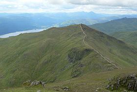
Beinn Ghlas is a mountain in the Southern Highlands of Scotland. It lies on the north shore of Loch Tay and is part of the Ben Lawers Range. It lies on the popular path to Ben Lawers from the National Trust for Scotland car park, with the result that many walkers traverse the summit of Beinn Ghlas without realising it. The popularity of the path meant that it suffered from severe erosion, but it has been reconstructed in recent years.
Map of Beinn Ghlas, Aberfeldy, UK
The Gaelic name is translated as 'grey-green mountain', which refers to the colour of the mica-schist that makes up the bulk of the mountain and that falls as a scree on its south-western side. The path up the mountain leads past outcrops of this rock that also reveal large garnets.
As mentioned above, the usual route to the summit leaves from the car park, follows Edramucky Burn, and climbs to the south-western ridge of the mountain. The deep corrie of Coire Odhar (the dun-coloured corrie) lies to the north. Walkers who continue on to Ben Lawers can avoid the 100 metre re-ascent of Beinn Ghlas on their return by taking the path that runs west of the summit, down to Coire Odhar.