
OS grid NN63904314 Elevation 1,118 m Easiest route Hiking | Topo map OS Landranger 51 Prominence 127 m Translation Scottish Gaelic | |
 | ||
Pronunciation Scottish Gaelic: [ən̪ˠˈs̪t̪uxk] Similar Meall Garbh, Meall Greigh, Beinn Ghlas, Meall Corranaich, Ben Lawers | ||
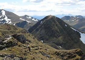
An Stùc is a conically shaped Scottish mountain in the Ben Lawers range to the north of Loch Tay. The normal routes of ascent are via the ridges from Ben Lawers or Meall Garbh.
Map of An St%C3%B9c, Aberfeldy, UK
There is another An Stùc in Assynt, standing at 364m about 17 miles northeast of Ullapool at the head of Glenoykel.
References
An Stùc Wikipedia(Text) CC BY-SA