
Postcode(s) 4829 Bedourie Diamantina Lakes Local time Thursday 2:09 AM | Postal code 4829 | |
 | ||
Population 283 (2011 census (including Birdsville)) Weather 30°C, Wind SE at 14 km/h, 27% Humidity | ||
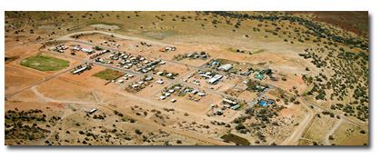
Bedourie is a small town and locality in the Shire of Diamantina, Queensland, Australia. In the 2011 census, Bedourie (including Birdsville) had a population of 283 people.
Contents
Map of Bedourie QLD 4829, Australia
Geography
Bedourier is located in the Channel Country of Central West Queensland, Australia, lying on Eyre Creek. It is located 1,600 kilometres (990 mi) west of the state capital, Brisbane, and 200 kilometres (120 mi) north of Birdsville.
Bedourie is the administrative centre of the Diamantina Shire, which also comprises the towns of Birdsville and Betoota.
When the Georgina River experiences severe floods the town can be cut off by road for months at a time.
History
Bedourie Post Office opened around July 1903 (receiving offices known as Bidouri, Bedouri and Bedourie had been open since 1887).
The Dianmantina Shire Council moved its headquarters from Birdsville to Bedourie in 1953.
At the 2006 census, Bedourie and the surrounding area had a population of 142. Twenty years earlier the town had 60 residents.
Heritage listings
Birdsville has a number of heritage-listed sites, including:
Amenities
Bedourie has an aquatic centre, library, museum, outback golf course, visitor information centre and a hotel built from adobe bricks in the 1880s and a racetrack.