
 | ||
Openrov dave murphy nova scotia bedford basin princess lodge boilers
Bedford Basin is a large enclosed bay, forming the northwestern end of Halifax Harbour on Canada's Atlantic coast. It is named in honour of John Russell, 4th Duke of Bedford.
Contents
- Openrov dave murphy nova scotia bedford basin princess lodge boilers
- Strange circular water waves in bedford basin in nova scotia
- GeographyEdit
- Secure convoy assemblyEdit
- Shoreline developmentEdit
- References
Strange circular water waves in bedford basin in nova scotia
GeographyEdit
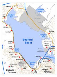
Geographically, the basin is situated entirely within the Halifax Regional Municipality and is oriented northwest-southeast, measuring approximately 8 kilometres long and 5 kilometres wide, surrounded by low hills measuring up to 160 metres (525 feet) in elevation, although most elevations range up to 30–60 m (100–200 ft).
The basin is quite deep with some areas measuring several dozen metres in depth; the good holding ground (mud) on the basin floor make it an ideal protected anchorage. The basin's geologic history can be traced to the Wisconsin Glaciation when it, along with "The Narrows", formed part of the pre-historic Sackville River valley.
The basin contains the following sub-basins:
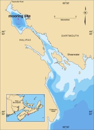
Bedford on the northwestern corner takes its name from the basin, while Dartmouth sits on its eastern shore and Rockingham occupies the majority of the western shore. Africville Park is situated on the southern shore near the entrance into The Narrows.
Secure convoy assemblyEdit
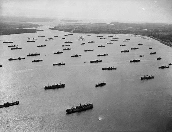
The basin came to international prominence during the First and Second World Wars when the German navy began to use submarines as an offensive weapon against Allied shipping. Canada's prominent role in the First World War led to Halifax being chosen as the primary logistic port for resupplying Western Europe. The protected waters of Bedford Basin allowed the Royal Navy and Royal Canadian Navy to assemble convoys consisting of hundreds of merchant ships in relative security while torpedo nets kept German submarines at bay.
Shoreline developmentEdit
The lands surrounding the basin are heavily developed with the only significant greenspace remaining being along the northeastern shore of the basin where a significant blast buffer zone surrounds Canadian Forces Ammunition Depot Bedford (CFAD Bedford); this is the Royal Canadian Navy's weapons magazine for its Atlantic fleet, known as Maritime Forces Atlantic (MARLANT).
The south shore of the basin at Fairview Cove hosts one of Halifax's two container terminals as well as Nova Scotia's largest railway yard, Rockingham Yard, operated by Canadian National Railway (CN).
The east shore of the basin hosts Burnside Industrial Park, the largest industrial park in HRM, as well as a bulk gypsum terminal at Wright's Cove and the Bedford Institute of Oceanography (which also derives its name from the basin) situated near the entrance to The Narrows.
The entire western shore to the head of the basin is fronted by a mix of residential/commercial and institutional developments.