
Time zone CET (UTC+1) Population 426 (2006) | Region Occitanie Area 36.82 km² Arrondissement Argelès-Gazost | |
 | ||
Intercommunality Vallée d'Argelès-Gazost | ||
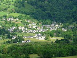
Beaucens (Occitan: Biussens) is a French commune in the Hautes-Pyrénées department in the Occitanie region of south-western France.
Contents
- Map of 65400 Beaucens France
- Geography
- Mapping
- Toponymy
- Administration
- Demography
- Civil heritage
- Religious heritage
- References
Map of 65400 Beaucens, France
The inhabitants of the commune are known as Beaucinois or Beaucinoises.
Geography
Beaucens is located in the Pyrénées National Park some 10 km south of Lourdes and 30 km south of Tarbes. Access to the commune is by the D913 from Préchac in the north which passes through the west of the commune and the village and continues south to join the D921 south-east of Soulom. The D13 goes north from the village to Ayros-Arbouix. Apart from the village there are the hamlets of Vielle, Gézat, and Nouillan. Most of the commune is rugged and inaccessible with some farmland in the west and forests south-east of the village. The Hautacam Ski resort is located in the centre of the commune
The Gave du Pau Ou du Lavedan flows through the west of the commune from south to north forming the Lac des Gaves before continuing north to become the Gave de Pau north of the commune. The Ruisseau des Bariquėres rises in the west of the commune and flows east to join the Gave du Pau Ou du Lavedan west of the village. The Ruisseau d'Estibos rises in the east of the commune and forms part of the north-eastern border before continuing west to join the Gave du Pau Ou du Lavedan. The Ruisseau d'Isaby flows east from the Lac d'Isaby forming part of the south-eastern border of the commune as it flows south-west to join the Gave de Gavarnie Ou de Pau at Soulom.
Mapping
A list of online mapping systems can be displayed by clicking on the coordinates (latitude and longitude) in the top right hand corner of this article.
Toponymy
Beaucens appears as Beaucen on the 1750 Cassini Map and the same on the 1790 version.
Administration
List of Successive Mayors
(Not all data is known)
Demography
In 2012 the commune had 421 inhabitants. The evolution of the number of inhabitants is known from the population censuses conducted in the commune since 1793. From the 21st century, a census of communes with fewer than 10,000 inhabitants is held every five years, unlike larger communes that have a sample survey every year.
Sources : Ldh/EHESS/Cassini until 1962, INSEE database from 1968 (population without double counting and municipal population from 2006)
Civil heritage
The commune has two buildings and sites that are registered as historical monuments:
Religious heritage
The Church of Saint Vincent contains two items that are registered as historical objects: