
Population (2010) 291 | Region Occitanie Area 2.72 km² | |
 | ||
Intercommunality Vallée d'Argelès-Gazost | ||
Ayros-Arbouix is a French commune in the Hautes-Pyrénées department in the Occitanie region of south-western France.
Contents
Map of 65400 Ayros-Arbouix, France
The inhabitants of the commune are known as Aybouisois or Aybouisoises.
Geography
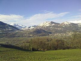
Ayros-Arbouix is part of the Pyrénées National Park and is located some 10 km south of Lourdes just east of Argelès-Gazost. Access to the commune is by road D821 from Lourdes which changes to the D913 at the commune border and passes down the western side of the commune continuing south to join the D921 near Villelongue. The D13 comes from Boô-Silhen in the north and passes through the centre of the commune before continuing south to Préchac. The D100 links the D821 to the D13 in the commune. Access to the village is by a country road east from the D13. Apart from the village there are the hamlets of Couture Bague south-west of the village and Arbouix in the south of the commune. The commune is mixed forest and farmland.
The Gave de Pau flows along the western border of the commune as it flows north to eventually join the Gave d'Oloron forming the Gaves Réunis at Peyrehorade. The Estau river flows west through the centre of the commune to join the Gave de Pau. The Ruisseau d'Aygueberden flows west though the south of the commune to join the Gave de Pau.
Administration
List of Successive Mayors
(Not all data is known)
Demography
In 2010 the commune had 291 inhabitants. The evolution of the number of inhabitants is known from the population censuses conducted in the commune since 1793. From the 21st century, a census of communes with fewer than 10,000 inhabitants is held every five years, unlike larger communes that have a sample survey every year.
Sources : Ldh/EHESS/Cassini until 1962, INSEE database from 1968 (population without double counting and municipal population from 2006)
Sports
The village has a green where Quilles de Neuf (Nine Bowls) is played.