
 | ||
The shoreline is where the land meets the sea and it is continually changing. Over the long term, the water is eroding the land. Beaches represent a special case, in that they exist where sand accumulated from the same processes that strip away rocky and sedimentary material. That is, they can grow as well as erode. River deltas are another exception, in that silt that erodes up river can accrete at the river's outlet and extend ocean shorelines. Catastrophic events such as tsunamis, hurricanes and storm surges accelerate beach erosion, potentially carrying away the entire sand load. Human activities can be as catastrophic as hurricanes, albeit usually over a longer time interval.
Contents
- Extraordinary processes tsunamis and hurricane driven storm surges
- Gradual processes
- Deltas
- Historical accretion of European beaches
- Modern beach recession
- Atlantic coast
- Ste
- California beaches
- Poland
- Aveiro
- The Netherlands
- Relative sea level changes
- Volcanism and earthquakes
- Gradual processes subsidence and uplift
- References
Extraordinary processes: tsunamis and hurricane-driven storm surges
Tsunamis, potentially enormous waves often caused by earthquakes, have great erosional and sediment-reworking potential. They may strip beaches of sand that may have taken years to accumulate and may destroy trees and other coastal vegetation. Tsunamis are also capable of flooding hundreds of meters inland past the typical high-water level and fast-moving water, associated with the inundating tsunami, can crush homes and other coastal structures.
A storm surge is an onshore gush of water associated with a low pressure weather system—storms. Storm surges can cause beach accretion and erosion. Historically notable storm surges occurred during the North Sea Flood of 1953, Hurricane Katrina, and the 1970 Bhola cyclone.
Gradual processes
The gradual evolution of beaches often comes from the interaction of longshore drift, a wave-driven process by which sediments move along a beach shore, and other sources of erosion or accretion, such as nearby rivers.
Deltas
Deltas are nourished by alluvial systems and accumulate sand and silt, growing where the sediment flux from land is large enough to avoid complete removal by coastal currents, tides, or waves.
Most modern deltas formed during the last five thousand years, after the present sea-level high stand was attained. However, not all sediment remains permanently in place: in the short term (decades to centuries), exceptional river floods, storms or other energetic events may remove significant portions of delta sediment or change its lobe distribution and, on longer geological time scales, sea-level fluctuations lead to destruction of deltaic features.
Historical accretion of European beaches
In the Mediterranean sea, deltas have been continuously growing for the last several thousand years. Six to seven thousand years ago, the sea level stabilized, and continuous river systems, ephemeral torrents, and other factors began this steady accretion. Since intense human use of coastal areas is a relatively recent phenomenon (except in the Nile delta), beach contours were primarily shaped by natural forces until the last centuries.
In Barcelona, for example, the accretion of the coast was a natural process until the late Middle Ages, when harbor-building increased the rate of accretion.
The port of Ephesus, one of the great cities of the Ionian Greeks in Asia Minor, was filled with sediment due to accretion from a nearby river; it is now 5 kilometers (3.1 mi) from the sea. Likewise, Ostia, the once-important port near ancient Rome, is now several kilometers inland, the coastline having moved slowly seaward.
Bruges became a port during the early Middle Ages and was accessible by sea until around 1050. At that time, however, the natural link between Bruges and the sea silted up. In 1134, a storm flood opened a deep channel, the Zwin, linking the city to the sea until the fifteenth century via a canal from the Zwin to Bruges. Bruges had to use a number of outports, such as Damme and Sluis, for this purpose. In 1907, a new seaport was inaugurated in Zeebrugge.
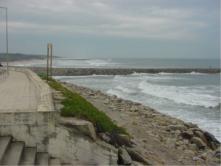
Modern beach recession
At the present time important segments of low coasts are in recession, losing sand and reducing beach dimensions. This loss can occur very rapidly. There are various reasons for beach recession, some more natural than others (degree of anthropization). Examples of this are occurring at Sète, in California, in Poland, in Aveiro (Portugal), and in the Netherlands and elsewhere along the North Sea. In Europe, coastal erosion is widespread (at least 70%) and distributed very irregularly.
Atlantic coast
Some of the coastal defence bunkers of the Atlantic Wall, built by the German soldiers during the Second World War at the top of the dunes are now underwater 2/3 of the times. It shows 200 meters of recession of the beach in 65 years.
Sète
The coast recession near Sète is related with coastal drift sand supply interruption due to growth of the Rhone delta, which (like most deltas) is becoming independent of the rest of the coast. The present lido shoreline is 210 meters away from the Roman lido.
California beaches
California's beaches and other shoreline features change according to the availability of beach sand, the wave and current energy impinging on the coast, and other physical processes that affect the movement of sand. A constant supply of sand is necessary for beaches to form and be maintained along this shoreline. Many human activities, including dam construction and river channelization, have reduced the supply of sand that reaches the ocean. This, in turn, has prevented beaches from being replenished and has thus created greater vulnerability for shorelines that have always been subject to varying levels of erosion. There are few practical solutions to improving sand supply from inland sources, so management of shoreline erosion will likely continue to focus at the land/sea interface along the California coastline.
Construction of breakwaters, jetties, or groyne fields to protect harbor entrances, maintain beaches, or protect coastal structures have both helped and harmed the movement of sand along the shoreline. Protective armoring formations trap sand and allow beaches to expand up-coast from the device, but can interrupt the flow of sand to beaches located down-coast.
Poland
During the last glaciation, the Baltic Polish area was covered in ice and associated morainal sediments. Deglaciation left a substantial amount of unconsolidated sediment. Currently, these unconsolidated sediments are strongly eroded and reworked by the sea.
Aveiro
The North Portuguese coast and its beaches were fed by large Iberian rivers. The massive building of dams in the Douro River basin has cut the sediment supply to the Aveiro coast, resulting in its recession. Hard protective works have been done all along.
The Netherlands
The Dutch coast consists of sandy, multi-barred beaches and can be characterised as a wave-dominated coast. Approximately 290 km of the coast consists of dunes and 60 km is protected by structures such as dikes and dams. With the melting of the ice at the end of the last ice age the coastline shifted eastward until about 5000 years ago the present position of the Dutch coastline was reached.
As the sea level rise stagnated, the sand supply decreased and the formation of the beach ridges stopped, after which when the sea broke through the lines of dunes during storms, men started to defend the land by building primitive dikes and walls. The dunes, together with the beach and the shoreline, offer a natural, sandy defence to the sea. About 30% of the Netherlands lies below sea level.
Over the last 30 years, approximately 1 million m³ sand per year has been lost from the Dutch coast to deep water. In most northern coastal sections, erosion occurs in deep water and also in the nearshore zone. In most southern sections, sedimentation occurs in the nearshore zone and erosion in deep water.
Structural erosion is due to sea level rise relative to the land and, in some spots, it is caused by harbour dams. The Dutch coast looked at as a single unit shows erosive behaviour. Approximately 12 million m³ of sand is transferred annually from the North Sea to the Wadden Sea as a result of relative rising sea level and coastal erosion.
Relative sea level changes
Several geological events and the climate can change (progressively or suddenly) the relative height of the Earth's surface to the sea-level. These events or processes continuously change coastlines.
Volcanism and earthquakes
Volcanic activity can create new islands. The 800 meters (2,600 ft) in diameter Surtsey Island, Iceland, for example, was created between November 1963 and June 1967. The island has since partially eroded, but it is expected to last another 100 years.
Some earthquakes can create sudden variations of relative ground level and change the coastline dramatically. Structurally controlled coasts include the San Andreas fault zone in California and the seismic Mediterranean belt (from Gibraltar to Greece).
The Bay of Pozzuoli, in Pozzuoli, Italy experienced hundreds of tremors between August 1982 and December 1984. The tremors, which reached a peak on October 4, 1983, damaged 8,000 buildings in the city center and raised the sea bottom by almost 2 meters (6.6 ft). This rendered the Bay of Pozzuoli too shallow for large craft and required the reconstruction of the harbour with new quays. The photo at the upper right shows the harbor before the uplift while the one on the bottom right shows the new quay.
Gradual processes: subsidence and uplift
Subsidence is the motion of the Earth's surface downward relative to the sea level due to internal geodynamic causes. The opposite of subsidence is uplift, which increases elevation.
Venice is probably the best-known example of a subsiding location. It experiences periodic flooding when extreme high tides or surges arrive. This phenomenon is caused by the compaction of young sediments in the Po River delta area, magnified by subsurface water and gas exploitation. Man-made works to solve this progressive sinking have been unsuccessful.
Mälaren, the third-largest lake in Sweden, is an example of deglacial uplift. It was once a bay on which seagoing vessels were once able to sail far into the country's interior, but it ultimately became a lake. Its uplift was caused by deglaciation: the removal of the weight of ice-age glaciers caused rapid uplift of the depressed land. For 2,000 years as the ice was unloaded, uplift proceeded at about 7.5 centimeters (3.0 in)/year. Once deglaciation was complete, uplift slowed to about 2.5 centimeters (0.98 in) annually, and it decreased exponentially after that. Today, annual uplift rates are 1 centimeter (0.39 in) or less, and studies suggest that rebound will continue for about another 10,000 years. The total uplift from the end of deglaciation may be up to 400 meters (1,300 ft).