
Admin. region Niederbayern Area 25.42 km² Population 1,740 (31 Dec 2008) | Time zone CET/CEST (UTC+1/+2) Local time Tuesday 5:41 PM Postal code 84092 | |
 | ||
Weather 3°C, Wind SE at 18 km/h, 96% Humidity | ||
Bayerbach is a municipality in the district of Landshut in Bavaria in Germany.
Contents
- Map of Bayerbach bei Ergoldsbach Germany
- Geography
- Subdivisions
- Neighbouring communities
- Main sights
- Sons and daughters of Bayerbach bei Ergoldsbach
- References
Map of Bayerbach bei Ergoldsbach, Germany
Geography
It is located on the Bayerbacher Bach, a stream which issues into the Kleine Laber.
Subdivisions
Bayerbach bei Ergoldsbach consists of 22 villages:
Neighbouring communities
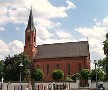
Main sights
Sons and daughters of Bayerbach bei Ergoldsbach
References
Bayerbach bei Ergoldsbach Wikipedia(Text) CC BY-SA