
Elevation 1,673 m Population 4,471 (2010) | Zip code 81636 Area code 970 | |
 | ||
Area 30.56 km² (30.04 km² Land / 52 ha Water) | ||
14 mesa vista place battlement mesa co 81635
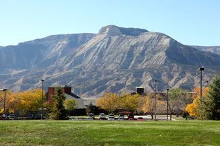
Battlement Mesa is a large prominent mesa in western Colorado in the United States. It sits along the Garfield-Mesa county line, between the Colorado River to the north and Plateau Creek to the south.
Contents
- 14 mesa vista place battlement mesa co 81635
- Map of Battlement Mesa CO 81635 USA
- Battlement mesa the colorado dream
- References
Map of Battlement Mesa, CO 81635, USA
It is visible south of Interstate 70, visible between the towns of Rifle and Parachute, stretching for approximately 15 miles (24 km) east-west. The community of Battlement Mesa along Interstate 70 takes its name from the mesa.
The mesa is similar in geology to the nearby Grand Mesa to the south, and to the Roan Cliffs to the north. It consists largely of a layer of basalt atop underlying layers of sedimentary rock, including a layer of the Green River Formation.
Battlement mesa the colorado dream
References
Battlement Mesa Wikipedia(Text) CC BY-SA