
Population 16,666 (2011 census) Area 8.25 km² Local time Thursday 2:39 AM | OS grid reference TQ2560 Sovereign state United Kingdom | |
 | ||
Weather 4°C, Wind W at 31 km/h, 67% Humidity Points of interest Oaks Park, Tumble Beacon, Slender Woods | ||
Banstead is a residential town/village in the borough of Reigate and Banstead in Surrey, England, on the border with London, 2.5 miles (4 km) south of Sutton, 5 miles (8 km) west of Croydon and 7.5 miles (12 km) south-east of Kingston-upon-Thames. The county town, Guildford is 17 miles (27 km) west south-west.
Contents
- Map of Banstead UK
- Demography
- History
- Economy
- Religion
- Education
- Primary
- Secondary
- Independent
- Transport
- Elevation and Soil
- Landmarks
- Demolished
- Open space
- In literature
- Notable residents
- References
Map of Banstead, UK
On the North Downs, Banstead is on three of the four main compass points separated from other settlements by open area buffers with Metropolitan Green Belt status. Echoing its much larger historic area and spread between newer developments, Banstead Downs is a Site of Special Scientific Interest (SSSI). Regarding its "town status", Banstead has never had the right to a regular (traditional) market; however it forms a post town.
Supporting interpretation as a village, one of its wards currently used is "Banstead Village". The ecclesiastical parish was abolished when its Urban District was created. Both included many outlying parts not only the part currently still associated heavily with today's village, contiguous Nork which contains Banstead station, is dependent on the amenities of Banstead and is included in for example county-level population analyses of Banstead.
Non-commercial in most areas of the economy, the nearest industrial or business areas are in the three more remote, urban towns above, as well as the closer Reigate-Redhill conurbation to the south, Sutton and Cheam to the north and Epsom, Leatherhead and Worcester Park to the west.
Demography
At the 2011 Census the population of Banstead (including Nork) was 16,666. The population of Banstead Village ward was 8,510 in 2001 and 9,110 in 2011. Banstead Parish now only exists for church purposes, there being no civil parish as it became an Banstead Urban District which was in turn abolished in 1965. Due to the aridity of the surface of the higher south, the old parish stretched far and wide to take in the width of the widest section of the North Downs and still today Banstead is drawn more widely than its narrow village or county or borough electoral wards and divisions under three measures:
Taking the last, broadest definition, in 2001, the upland settlements loosely associated with Banstead such as Tadworth had some 46,280 people across an area of approximately 16 square miles (41 km2) (four miles by four miles).
The ward of Nork includes areas which were not historically part of the hamlet of Nork. At the 2011 Census it had 7,556 residents.
The area historically had many other hamlets, which gradually gained their own village or town status; they stretched as far as Reigate across the widest part of crest of the North Downs. Thus historic demography does not give a fair indicator of population change. Identifying this swathe of land in 21st century figures with the parish, historical population growth is as follows, with parts of Walton-on-the-Hill and Chipstead included in the 2001 and 2011 wards:
The average level of accommodation in the region composed of detached houses was 28%, the average that was apartments was 22.6%.
The proportion of households who owned their home outright compares to the regional average of 35.1%. The proportion who owned their home with a loan compares to the regional average of 32.5%. The remaining % is made up of rented dwellings (plus a negligible % of households living rent-free).
History
The earliest recorded mention of Banstead was in an Anglo-Saxon charter of AD 967, in the reign of King Edgar.
The settlement appears in the Domesday Book (1086) as Benestede. The first element is probably the Anglo Saxon word bene, meaning bean, and the second element stede refers to an inhabited place without town status (cf farmstead).
Banstead's non-ecclesiastical land and 50 households were held by Richard as tenant-in-chief, under the Bishop of Bayeux. Its assets were: 9½ hides, 1 church, 1 mill worth £1, 17 ploughs, woodland worth 20 hogs. It rendered (in total): £8 per year.
The Manor had two ploughs, and there were 28 villeins and 15 cottars (people with a small cottage but no land) with 15 ploughs.
This was a farming area that later became well known for its high quality wool. The manor was owned by increasingly wealthy gentry, then by the church, before it fell into the hands of the Crown in the 13th century; Edward I visited more than once. Henry VIII made Banstead part of Catherine of Aragon's dowry, but took it away again and gave it to a court favourite, Sir Nicholas Carew. Carew was later beheaded for treason, but the manor, once covering most of the village but mostly sold piecemeal, stayed in his family until the 18th century.
Banstead Downs, which for many centuries meant all the open land stretching from Epsom to Croydon and Reigate, became well known for horse racing in the 17th century. On 20 November 1683, King Charles II and the Duke of York attended a race meeting near the core of the village. The town also gained a reputation as a health resort during that era, becoming famous for its "wholesome air", and London physicians recommended a visit to Banstead to their ailing patients.
Banstead's population remained low until the late 19th century when the improved roads and the building of the railways led to gradual growth, which continued with low density social housing and post-Blitz rehousing projects in the mid 20th century. Banstead's housing stock is generally low density and set in overwhelmingly green surroundings; there are a few listed buildings of some historical and architectural interest Banstead was a spring line settlement's whose main source of water was The Old Well until the arrival of pumped water. The 18th century wellhead cover which still houses the elaborate winding gear is a listed building.
In 1930, the ecclesiastical parish of Nork was formed, taking in part of Epsom as far as Wallace Fields and Higher Green in the west of the parish, loosely termed Epsom Downs.
Economy
The centre of Banstead has a modest High Street which stretches from the war memorial to the public library, with a churchyard on part of the south side. Scouts and Guides parade the street on Remembrance Day and May Day. On 12 December 2008, a large fire destroyed the Waitrose supermarket rendering it structurally flawed. While the store was being rebuilt, Waitrose operated a temporary store in the High Street, in the former Woolworths store. The rebuilt store opened on 26 November 2009. There are various restaurants and coffee bars as well as largely upmarket independent stores and the professional offices: six estate agencies, three firms of solicitors and a notary public.
In addition to employment in the retail sector in the High Street, there are a small number of public sector jobs: in the local authority offices and NHS facilities to the west of the Banstead's centre, and in various schools across the area. However, the majority of Banstead's residents commute out of the district for employment: annual exits from the town's station rose from 93,069 in the tax year 2004-05 to 128,148 in 2011-12.
Religion
Banstead has several churches. All Saints' Church and Banstead Baptist Church (now known as ChristChurch Banstead since September 2013) are on the high street. Within the area there is also Banstead Community Church, St Ann's Roman Catholic Church, the Methodist Church, St Paul's Church and the United Reformed Church.
Education
There are several schools in and around Banstead. Further education is not available in the town, most students go to institutions in Sutton, Epsom or Reigate.
Primary
Secondary
Neighbouring London Borough of Sutton has five grammar schools, which accept pupils from outside the borough.
Independent
Transport
Elevation and Soil
Much of the land is at about 125 m above sea level and as this descends to about 100 m it is bisected by a railway line in a relatively deep cutting.
Underneath a variable depth humus topsoil, most of the village is on various flints or chalk.
Landmarks
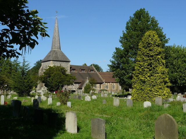
Foremost among the listed buildings is the Grade II-listed parish church of All Saints, made of knapped flint, partially dressed in stone, with its sturdy tower and medieval spire. It was built in the 12th and 13th centuries, and restored by George Edmund Street in 1861.
The church of All Saints was built on a site donated by Nigel de Mowbray, Lord of the Manor. The West window was designed by Dante Gabriel Rossetti and produced by William Morris.
The spire of All Saints was the measuring point that was aimed at from Hounslow Heath for the base-line for calculating the precise distance and relationship between the Royal Greenwich Observatory and the Paris Observatory. This Anglo-French Survey (1784–1790) was the forerunner of the mapping of the entire country, and was led by General William Roy. A nearby viewpoint called Hundred Acres was used to make sightings south to Botley Hill, east to Upper Norwood, west to Chertsey, and so forth.
The old village well stands to the east of the town centre in Woodmansterne Lane. It is almost 300 feet (90 m) deep and was last used around the end of the 19th century. The wellhead cover dates from the 18th century and still contains the winding gear.
Nork Park contains the remains of the Colman family mansion (associated with Colman's Mustard). Many apple trees survive from the original orchard.
A large mound off The Drive, close to the Beacon School, is known as the Tumble Beacon. Originally a Bronze Age bowl barrow, it was enlarged circa the sixteenth century, and is believed to have been the site of one of a series of beacons/bonfires that stretched from the south coast towards London warning of the arrival of the Spanish Armada.
Demolished
On the site of Downview and Highdown Prisons once stood the Banstead Asylum, a psychiatric hospital from 1873 to 1986. After being involuntarily committed to the Asylum in the late 1960s, Vincent Crane of the band Atomic Rooster wrote the song "Banstead," which featured on the 1970 album Atomic Roooster.
Open space
Banstead Downs is a large Site of Special Scientific Interest, covering 430 acres (170 ha). Banstead Golf Course is on the northern slopes. The Downs is one of four green areas in the north of the borough, which are overall referred to by their historic name "Banstead Commons"; the other three are:
Banstead Downs is home to the rare Small Blue butterfly. The four tumuli (burial mounds) that can be seen on the Downs have been identified as dating from Saxon times and are known as the Gally Hills because they are the site of a 15th-century gallows.
In literature
Banstead appears as a destination in the 1895 novel The Time Machine by H. G. Wells and also gains a brief mention in another of his novels, The War of the Worlds.