
Traversed by SH-29, S-324 | Elevation 2,342 m | |
 | ||
Similar Lemhi Pass, Chief Joseph Pass, Monida Pass, Rocky Mountains, Targhee Pass | ||
Bannock Pass is a high mountain pass in the Beaverhead Mountains, part of the Bitterroot Range in the Rocky Mountains. The pass lies on the Montana-Idaho border on the Continental Divide, at an elevation of 7684 ft (2342 m) above sea level.
Contents
Map of Bannock Pass, Idaho 59725, USA
The pass is crossed by a road (Idaho State Highway 29 and Montana Secondary Highway 324) from Leadore, Idaho to Dillon, Montana.
Bannock Pass should not be confused with the similarly named Bannack Pass, about 33 miles to the southeast, which is also in the Beaverhead Mountains, on the Montana-Idaho border, and on the Continental Divide, and which has virtually the same elevation (7679 ft or 2341 m).
HistoryEdit
Bannock Pass is named for the Bannock Native American people.
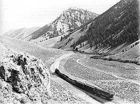
In 1909 and 1910 the Gilmore and Pittsburgh Railroad was constructed through the area. In order to keep the grades manageable, the railroad used a switchback on each side of the ridge and bored a tunnel under the summit somewhat east of the current highway crossing. The railroad was abandoned in 1939.