
Population 5,773 (2015) | Postcode(s) 3350 State electorate(s) BuninyongWendouree Postal code 3350 | |
 | ||
Location 3 km (2 mi) from Ballarat Central | ||
10 latitude court ballarat east victoria 3350
Ballarat East is a suburb of Ballarat in Victoria, Australia. The suburb covers a large area east of the City of Ballarat. It is the oldest area in Ballarat and, between 1859 and 1921, was once also a municipality known as Ballarat East, under its own council, the Ballarat East Town Council. The population of Ballarat East was estimated to be 5,733 in 2015. Although amalgamation occurred nearly a century ago, many residents still perceive themselves as distinct from other "Ballaratians" and as 'working class'. The residents of Ballarat East played an integral role in the Eureka Rebellion and Battle of Eureka Stockade, although the site of this battle is now an island suburb within the East called Eureka. Much of the suburb is subject to heritage overlays because of its local significance, with most dwellings dating between the 1860s and 1940s.
Contents
- 10 latitude court ballarat east victoria 3350
- Map of Ballarat East VIC 3350 Australia
- 190b victoria street ballarat east victoria 3350
- History
- Municipal status town hall and civic centre
- Local identity and heritage
- Parks and commons
- Sporting
- Ballarat Community Garden
- Transport
- Notable persons
- References
Map of Ballarat East VIC 3350, Australia
190b victoria street ballarat east victoria 3350
History
The discovery of goldfields in 1851 led to heavy immigration. In 1854, in their resistance of an arbitrary tax, gold miners in the area came into armed conflict with the authorities. A commission was appointed to investigate their grievances and a charter was granted to the town in 1855. Ballarat East Post Office opened on 1 December 1857 and was replaced by the Bakery Hill office in 1992.
The Ballarat East goldfield, which consisted of three distinct areas known as Ballarat East, Ballarat West and Nerrina, produced over 1.9 million ounces of gold from vein systems and over 16 million ounces from adjacent alluvial deposits. At the turn of the 20th century, these alluvial goldfields were the richest ever opened. As these surface deposits were exhausted the quartz reefs at deep levels were exploited and several mines worked at depths exceeding 600 metres.
Main Street developed into the principal commercial area in the Ballarat district. Its mostly tents and timber buildings were destroyed by a series of fires during the 1860s and the commercial area shifted to the planned area of Ballarat West, specifically Sturt and Lydiard Streets.
Municipal status, town hall and civic centre
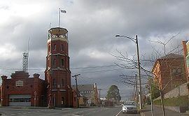
Ballarat East was one of the first areas of Ballarat to gain municipal status. In 1859 the newly formed Ballarat East Town Council acquisioned land in what was to become the Barkly Street civic area and on 26 December 1861 the foundation stone was laid for the Ballarat East Town Hall which was built in a Renaissance Revival architecture style and set in formal gardens. It was completed the following year along with the Ballarat East Free Library next door and the Ballarat fire station, a new headquarters for the fire brigade formed in 1856) was erected a few years later in 1864.
Ballarat East had its own railway station in the 1860s (only the goods sheds remain), built shortly after Ballarat West's station. It became an important junction for branch lines before being closed in the 1960s and its platforms demolished.
The East Ballarat Town Council was amalgamated with Ballarat West Town Council in 1920-1921 to become the City of Ballarat. After this time there was indecision as to how to use the old hall. In 1927 the Ballarat Teachers College moved there however during the great depression the town hall was mostly unused and was finally demolished in 1936 after years of speculation of its use as a girls' school or headquarters for the Ballarat Historical Society. The gates to the hall's once extensive gardens remain.
Local identity and heritage
Residents of old Ballarat East were known for their determined, working class spirit arising from its traditional poverty. In large part the poverty of the area discouraged the kinds of development experienced in other suburbs of Ballarat, especially in the 1970s and 1980s. As a result, much of the residential and business architecture of Ballarat East still exists from the 1860s through to early 1940s, with tree lined streets and grassy verges (nature strips), as well as bluestone canals. There are numerous heritage overlays placed on much of the East, including the Humffray Street Heritage Precinct near Black Hill where 66% of dwellings are declared to be of local heritage significance or contributory significance. According to the council's heritage survey, "[t]he particular mining character of this area is important to Ballarat as it retains the atmosphere of an early mining settlement more strongly than elsewhere".
According to historian Weston Bate in his 1978 work the Lucky City: the first generation of Ballarat:
"[T]he tone of the East was strident and individual. It would never willingly be a suburb of Ballarat West. The two co-existed like the head and tail of a coin, looking in different directions and displaying the contrasting imprints of the historical and geographical dies that had made them. Each was a guardian of an aspect of Ballarat’s tradition, and the community as a whole was undoubtedly more meaningful and interesting as a result. It might be thought the East was more Australian because it was less subjected to imported urban forms and institutions and had a restless larrikin quality. Yet the West was probably more typical of what British migrants hoped for in Australia – material success – and it contained large numbers of pioneers who had had the best of both worlds…"
While mining has not been undertaken in the East for some time, the extensive mining that occurred in the 1800s still impacts residents. For example, poorly conceived mine shafts that were not registered at the time have been known to reopen leaving holes in the ground. This is particularly true of properties around Black Hill as well as on the Hill itself, where walkers should not stray from established paths. Mullock piles, containing mine tailings, were once dispersed in order to flatten land for residential dwellings. This has led to elevated arsenic levels in the soil which necessitates residents in certain areas growing fruit and vegetables in elevated garden beds. Some lots on Morres Street North are still vacant because of the contamination.
Parks and commons
Ballarat East is home to many parks, commons, and reserves, as well as a golf course and historic oval. The parks include: Eastern Oval, once the only such park, Ballarat Wildlife Park, McKenzie Reserve, Len T. Fraser Reserve, Pennywright Park, Railway Reserve and Webb Avenue Park.
Sporting
At its furthest west point, East Ballarat is home to the historic Eastern Oval, with its Edwardian grandstands. The Oval hosts Australian rules football and cricket matches, and is the home of the Ballarat Cricket Association. The stadium is also home to the East Point Football Club of the Ballarat Football League and also the Golden Point Cricket Club and has also been mooted as a potential Australian Football League venue. The recreational facility also includes netball courts, as well as the lawn bowls club, Ballarat East Bowling Club, and other club facilities. Golfers play at the course of the Mount Xavier Golf Club on Fortune Street.
Ballarat Community Garden
Created in 2004, the community garden is located on the corner of Queen Street and Dyte Parade - near the old site of the old railway station - and is managed by the Ballarat City Council. Members have access to their own 3x3 metre bed, as well as sheds, toilets and chook yard. An annual Harvest Festival in autumn is held where locals can buy plants and produce.
Transport
The main form of transport is the automobile, as well as V/Line train for commuters to Melbourne. The suburb has several key collector roads. The largest road is Victoria Street (named for Queen Victoria), a dual carriageway which forms the main eastern entrance to Ballarat. In the north is Humffray Street (named for local politician John Basson Humffray), which forms a major east-west route. In the west is Main Road and Barkly Street (named for the Victorian Governor, Sir Henry Barkly). Along the south is another major east-west route, Eureka Street. Buses provide the only means of public transport and several services are available. Route 8 (Eureka) and 9 (Canadian) travel along Eureka Street, while Route 7 (Brown Hill) service runs along Humffray and Victoria Streets. Route 10 (Buninyong) services part of the western edge along Main Road. Although the Ballarat-Melbourne railway runs the length of the suburb, the local railway station, once an important interchange, located near the Humffray Street level crossing, was closed in the 1960s and has been largely demolished. Ballarat railway station is located near the eastern boundary of Ballarat East and provides regular services to Ararat (The Overland to Adelaide), Maryborough, and Melbourne (Southern Cross Station).
Notable persons
Russell Mark, 1996 Olympic Gold Medallist in Shooting.