
Population 173 (2011 census) Postal code 3350 | Postcode(s) 3350 State electorate(s) BuninyongWendouree Area 25 ha Federal division Division of Ballarat | |
 | ||
Location 0.5 km (0 mi) from Ballarat Central | ||
Bakery Hill is an inner city suburb of Ballarat in Victoria, Australia. It is the smallest suburb in the city of Ballarat in terms of both area and population, which at the 2011 census was just 173 people.
Map of Bakery Hill VIC 3350, Australia
The boundary of Bakery Hill is Peel Street to the west; Mair Street to the north; East Street to the east and Steinfield Street to the south. It was officially gazetted from Ballarat in 1992.
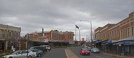
It is a primarily commercial area, including a portion of the eastern CBD with a restaurant precinct of Bridge Mall and key commercial precincts around Main Road, Peel Street and Mair Street as well as accommodation businesses and around 70 homes, mostly miners cottages in the surrounding streets.
The suburb is situated around and named after the hill of the same name which in turn was named due to the location of the early settlement's main bakery.
Bakery Hill is one of the most historic places in Ballarat and important culturally to the city. It is the place of the meeting before the Eureka Stockade where insurgents swore the Eureka oath - their allegiance to the Southern Cross on 1 December 1854. It was also one of the richest mining leads in Australia, the place of discovery of the Welcome Nugget on 9 June 1858.
The Bakery Hill Secondary College, located on East Street, was closed in the 1990s during the Kennett era rationalisation of the education system and is now an antiques centre. The suburb has a kindergarten.