
Founded 1838 Time zone PST (UTC+8) Local time Wednesday 6:37 AM | District 3rd District Barangays Area 25 km² | |
 | ||
Weather 25°C, Wind NE at 8 km/h, 88% Humidity | ||
Balete batangas thumbs up tv feature part 2
Balete, officially the Municipality of Balete (Filipino: Bayan ng Balete), is a municipality in the province of Batangas in the Calabarzon (Region IV-A) of the Philippines. The population was 22,661 at the 2015 census. In the 2016 electoral roll, it had 12,250 registered voters.
Contents
- Balete batangas thumbs up tv feature part 2
- Map of Balete Batangas Philippines
- Geography
- Barangays
- Demographics
- References
Map of Balete, Batangas, Philippines
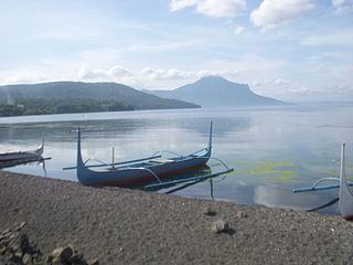
Balete is well known for its location on Taal Lake, providing a panoramic view of the Taal Volcano. The pilgrimage site Marian Orchard is located in Barangay Malabanan.
On February 13, 2008, incumbent Mayor David Pamplona was assassinated in Barangay Bulihan, Malvar.
Geography
Balete is located at 14°01′N 121°06′E.
According to the Philippine Statistics Authority, the municipality has a land area of 25.00 square kilometres (9.65 sq mi) constituting 6999800000000000000♠0.80% of the 3,119.75-square-kilometre- (1,204.54 sq mi) total area of Batangas.
Barangays
Balete is politically subdivided into 13 barangays.
Demographics
In the 2015 census, Balete had a population of 22,661. The population density was 910 inhabitants per square kilometre (2,400/sq mi).
In the 2016 electoral roll, it had 12,250 registered voters.