
Founded 19 August 1609 Time zone PST (UTC+8) Number of airports 1 | District Lone District Barangays Area 92.55 km² Local time Wednesday 6:32 AM | |
 | ||
Weather 25°C, Wind NE at 8 km/h, 86% Humidity Neighborhoods Suclayin, Calabuanan, Barangay 5, Barangay 3, Barangay 4, Buhangin, Obligacion, Barangay 2, Barangay 1 Points of interest Sabang Beach, Museo de Baler, Ermita Hill, Cemento Beach, Bahia de Baler Garden R | ||
Baler aurora
Baler, officially the Municipality of Baler (Filipino: Bayan ng Baler; Ilocano: Ili ti Baler), is a municipality in the province of Aurora in the Central Luzon (Region III) of the Philippines, serving as the provincial capital. The population was 39,562 at the 2015 census. In the 2016 electoral roll, it had 22,535 registered voters.
Contents
- Baler aurora
- Map of Baler Aurora Philippines
- Spanish colonial period
- American colonial period
- Japanese occupation
- Post war period
- Geography
- Barangays
- Demographics
- Notable people
- Twin towns Sister cities
- References
Map of Baler, Aurora, Philippines
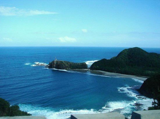
Baler is located 231 kilometres (144 mi) north-east of Manila via a mountain pass accessible by bus and private vehicle. It is host to spectacular geographic formations and is situated on a vast plain at the south end of Baler Bay, a contiguous segment of the Philippine Sea.
It became the capital of Aurora on 14 June 1951 under Republic Act No. 648 signed by President Elpidio R. Quirino. It remained the seat of government of Aurora on 21 November 1978 under Batas Pambansa Blg. 7 signed by President Ferdinand E. Marcos.
It was identified by Google in 2009 as topping the list of beach destinations in the Philippines. It was described by Yahoo! Southeast Asia in March 2013 as one of the "top surf spots" in the Philippines. Nine-feet waves serve as its main tourist asset, attracting hundreds of surfers during the surfing season from September to February.
Spanish colonial period
In 1609, seven Franciscan missionaries, led by Fray Blas Palomino, founded the settlement of Baler, which was later converted into a pueblo (town) by the Augustinians and the Recollects in 1658. Due to scarcity of religious missionaries, the Franciscans again took over the administration of the settlement in 1703.
On 27 December 1735, a great storm came and a huge wave called tromba marina devastated the old town settlement, then located in Barrio Sabang. Among the survivors were the Angaras, Bijasas, Bitongs, Lumasacs, Carrascos, and Pobletes who swam toward the nearby Ermita Hill. A new community sprang into what is now the Poblacion of Baler, leaving "Kinagunasan," the place of devastation.
On 27 June 1898, 15 days after the Philippine Independence was proclaimed, 54 Spanish soldiers of the Baler garrison, under the command of Captain Enrique de las Morenas y Fossi, made the San Luis Obispo de Tolosa church their barracks. When Captain De las Morenas died on 22 November 1899, Lieutenant Saturnino Martin Cerezo replaced him. On 2 June 1899, the last Spanish garrison in the Philippines surrendered after the Siege of Baler, effectively ending over 300 years of Spanish rule in the country.
American colonial period
In 1901, the Americans incorporated the town into the province of Tayabas (later named Quezon province). Before the Americans came, Baler was under the district of El Príncipe.
The Comedia de Baler of Aurora mounted its first production in 1927. It was supported by then President Manuel Luis Quezon and enjoyed the collaboration of artists Fortunato Esoreña and Alejandro Ferreras and arnis expert Antonino Ramos. Still alive until today, it features a group of colorfully attired performers using authentic weapons, like swords and knives, in their plays.
Japanese occupation
In 1942, Japanese troops entered Baler, where they made the Baler Elementary School building as their garrison under the command of a certain Captain Hattori. The general headquarters and camp base of the Philippine Commonwealth Army from 3 January 1942 to 30 June 1946 and the Philippine Constabulary from 28 October 1944 to 30 June 1946 were stationed in Baler. In 1945, Filipino and American troops landed in Baler, including Filipino troops of the 3rd Infantry Division, the 5th Infantry Division, the 51st Infantry Division, and the 52nd Infantry Division of the Philippine Commonwealth Army, the 5th Infantry Regiment of the Philippine Constabulary, the local recognized guerrilla unit, and the American troops of the 6th Infantry Division of the United States Army. The retreating Japanese troops destroyed the San Luis Obispo de Tolosa Church in Baler.
Post-war period
On 14 June 1951, by virtue of Republic Act No. 648, Baler became the capital town of the sub-province (and later, province) of Aurora.
In 1956, the barrio of Dingalan was converted into a municipal district within Baler and later became a town in its right.
Geography
Baler is located at 15°45′30″N 121°33′45″E.
According to the Philippine Statistics Authority, the municipality has a land area of 92.55 square kilometres (35.73 sq mi) constituting 7000294000000000000♠2.94% of the 3,147.32-square-kilometre- (1,215.19 sq mi) total area of Aurora.
Barangays
Baler is politically subdivided into 13 barangays.
Demographics
In the 2015 census, Baler had a population of 39,562. The population density was 430 inhabitants per square kilometre (1,100/sq mi).
In the 2016 electoral roll, it had 22,535 registered voters.