
Population 0 | Width 9 km (5.6 mi) Max length 15.4 km | |
 | ||
Highest point unnamed location on Low Cay2 metres (6.6 ft) Department San Andrés and Providencia Territory unorganized, unincorporated | ||
Bajo Nuevo Bank, also known as the Petrel Islands (Spanish: Bajo Nuevo, Islas Petrel), is a small, uninhabited reef with some small grass-covered islets, located in the western Caribbean Sea at 15°53′N 78°38′W, with a lighthouse on Low Cay at 15°51′N 78°38′W. The closest neighbouring land feature is Serranilla Bank, located 110 kilometres (68 miles) to the west.
Contents
Map of Bajo Nuevo Bank
The reef was first shown on Dutch maps dating to 1634 but was given its present name in 1654. Bajo Nuevo was rediscovered by the English pirate John Glover in 1660. Although the bank is currently controlled by Colombia, it is subject to a sovereignty dispute involving Jamaica, Nicaragua, and the United States.
Geography
Bajo Nuevo Bank is about 26 km (16 mi) long and 9 km (5.6 mi) wide. The satellite image shows two distinct atoll-like structures separated by a deep channel 1.4 km (0.87 mi) wide at its narrowest point. The larger southwestern reef complex measures 15.4 km (9.6 mi) northeast-southwest, and is up to 9.4 km (5.8 mi) wide, covering an area of about 100 km2 (39 sq mi). The reef partially dries on the southern and eastern sides. The smaller northeastern reef complex measures 10.5 km (6.5 mi) east-west and is up to 5.5 km (3.4 mi) wide, covering an area of 45 km2 (17 sq mi). The land area is minuscule by comparison.
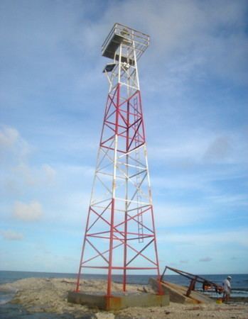
The most prominent cay is Low Cay, in the southwestern atoll. It is 300 m (330 yd) long and 40 m (44 yd) wide (about 1 ha or 2.5 acres), no more than 2 m (6.6 ft) high, and barren. It is composed of broken coral, driftwood, and sand. The light beacon on Low Cay is a 21 m (69 ft) metal tower, painted white with a red top. It emits a focal plane beam of light as two white flashes of light every 15 seconds. The beacon was erected in 1982, and reconstructed by the Colombian Ministry of Defence in February 2008. It is currently maintained by the Colombian Navy, and overseen by the state's Maritime Authority.
Territorial dispute
Bajo Nuevo Bank is the subject of conflicting claims made by a number of sovereign states. In most cases, the dispute stems from attempts by a state to expand its exclusive economic zone over the surrounding seas.
Colombia currently claims the area as part of the department of San Andrés and Providencia. Naval patrols in the area are carried out by the San Andrés fleet of the Colombian Navy. Colombia maintains that it has claimed these territories since 1886, as part of the geographic archipelago of San Andrés and Providencia. This date is disputed by other claimant states, most prominent among them Nicaragua, which has argued that Colombia had not claimed the territory by name until recently.
Jamaica's claim has been largely dormant since entering into a number of bilateral agreements with Colombia. Between 1982 and 1986, the two states maintained a formal agreement which granted regulated fishing rights to Jamaican vessels within the territorial waters of Bajo Nuevo and nearby Serranilla Bank. Jamaica's signing of this treaty was regarded by critics as a de facto recognition of Colombian sovereignty over the two banks. The treaty is now extinguished, however, as Colombia declined to renew it upon its expiration in August 1986.
In November 1993, Colombia and Jamaica agreed upon a maritime delimitation treaty establishing a "Joint Regime Area" to cooperatively manage and exploit living and non-living resources in designated waters between the two aforementioned banks. However, the territorial waters immediately surrounding the cays themselves were excluded from the zone of joint-control, as Colombia considers these areas to be part of her coastal waters. The exclusion circles were defined in the chart attached to the treaty as "Colombia's territorial sea in Serranilla and Bajo Nuevo". The agreement came into force in March 1994.
Nicaragua lays claim to all the islands on its continental shelf, covering an area of over 50,000 km2 in the Caribbean Sea, including Bajo Nuevo Bank and all islands associated with the San Andrés and Providencia archipelagoes. It has persistently pursued this claim against Colombia in the International Court of Justice (ICJ), filing cases in both 2001 and 2007. The main cause of the dispute lies in the debated validity and applicability of the Esguerra-Bárcenas treaty, exchanged with Colombia in March 1928.
The United States claim was made on 22 November 1869 by James W. Jennett under the provisions of the Guano Islands Act. Most claims made by the U.S. over the guano islands in this region were officially renounced in a treaty with Colombia, dated September 1972. But whether or not Bajo Nuevo Bank was included in the agreement is disputed, as the bank is not mentioned specifically by name within the treaty, and Article 7 of the treaty states that matters not specifically mentioned in the treaty are not subject to its terms. The U.S. administers the bank as an unorganized, unincorporated United States territory.
Honduras, prior to its ratification of a maritime boundary treaty with Colombia on 20 December 1999, had previously also laid claim to Bajo Nuevo and nearby Serranilla Bank. Both states agreed upon a maritime demarcation in 1986 that excluded Honduras from any control over the banks or their surrounding waters. This bilateral treaty ensured that Honduras implicitly recognises Colombia's sovereignty over the disputed territories. Honduras' legal right to hand over these areas was disputed by Nicaragua before the ICJ.
On November 19, 2012, in regards to Nicaraguan claims to the islands the International Court of Justice (ICJ) found, unanimously, that the Republic of Colombia has sovereignty over Bajo Nuevo.