Frazioni Berzi, Vignai Demonym(s) Baiardesi or Bajocchi Area 24.54 km² Postal code 18031 | Elevation 900 m (3,000 ft) Time zone CET (UTC+1) Local time Tuesday 5:47 PM Dialling code 0184 | |
 | ||
Weather 8°C, Wind SW at 32 km/h, 83% Humidity | ||
Bajardo (also Baiardo) is a comune in the Province of Imperia in the Italian region Liguria. At the start of 2008 it had 306 inhabitants: less than a fifth of those counted in 1911. It is about 110 kilometres (68 mi) southwest of Genoa and about 25 kilometres (16 mi) west of Imperia.
Contents
Map of 18031 Bajardo Province of Imperia, Italy
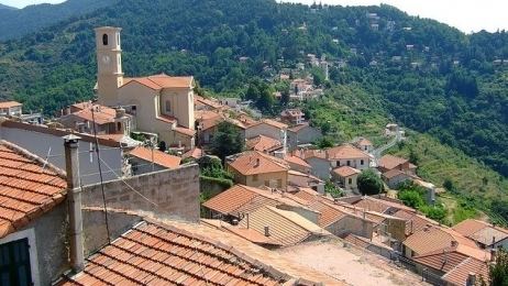
Its principal settlement, Bajardo itself, is a medieval village which stands at an elevation of 900 metres (3,000 ft) on a peak at the head of the basin of the Nervia torrent.
History
First ruled by the Counts of Ventimiglia, it passed to the Marquis of Ceva before coming under Genoese control in 1259. It remained with Genoa until 1815 when it became part of the Kingdom of Sardinia. The parish church of San Nicolò da Bari in Piazza Parrocchiale was built in 1893 to replace the church destroyed by the earthquake of 1887.
Traditions
Every year, various festivals are held in Bajardo . One occurs in June in remembrance of an event from hundreds of years ago. One of the ruling lords was engaged to a woman. However, this woman was much younger and had a secret lover. One day, the secret lover and the woman attempted to escape into the woods. However, the rich lord sent for them. When found, she was decapitated. What happened to the secret lover is unknown. In remembrance, Bajardo holds a tree-cutting festival at the beginning of every June. The townspeople set up the tree in the central square, have various festivities throughout the day, and two weeks later chop down the tree.
