
Archipelago Babuyan Islands Width 6 mi (10 km) Highest elevation 3,543 ft (1,079.9 m) | Length 8 mi (13 km) Coastline 24 mi (39 km) | |
 | ||
Adjacent bodies of water Balintang ChannelLuzon Strait | ||
Babuyan Island (sometimes called Babuyan Claro) is the highest and northernmost island in the Babuyan Islands in Luzon Strait north of Luzon Island in the Philippines. The whole island makes up the barangay of Babuyan Claro, that constitute the municipality of Calayan in Cagayan province. The volcanic island has a population of 1,423 as of the 2010 Census.
Contents
Map of Babuyan Islands, Philippines
Geography
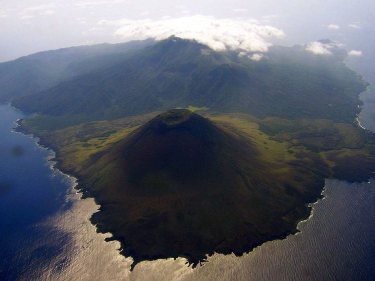
Babuyan Island lies about 27 mi (43 km) south-southwestward of Balintang Islands, and about 55 mi (89 km) northward of Cape Engaño Lighthouse. The nearly triangular island is about 8 mi (13 km) long in a northeast and southwest direction, with an average width of about 6 mi (9.7 km) miles. The island seems to be steep all around. A reef projects from its western point. The south point is steep and rocky with a black, rocky, sugarloaf islet, called Pan de Azucar, close inshore.
Volcanoes
Near the western point of the island is Smith Volcano, also known as Mount Babuyan, about 2,257 ft (688 m) high. In the middle of the island and east-southeastward from Smith is Babuyan Claro, also known as Mount Pangasun, about 3,543 ft (1,080 m) high, between which the mountains are much lower, so that from a considerable distance eastward it appears as a round mountain with a detached hillock northward. There are three other volcanic cones with no historic eruptions on the island - Cayonan, Dionisio and Naydi.