
- location Atlantic Ocean Geology Trachyte | - elevation 0 m (0 ft) Phone +351 292 293 525 Period Holocene | |
 | ||
Hours Closed today SundayClosedMonday9AM–5:30PMTuesday9AM–5:30PMWednesday9AM–5:30PMThursday9AM–5:30PMFriday9AM–5:30PMSaturdayClosed Similar Lagoa do Congro, Pico das Camarinhas, TERRAvita Nature Park, Capelinhos, Algar do Carvão Profiles | ||
Azores geopark promotional video in hd
The Azores Geopark (Portuguese: Geoparque Açores) is a network of 121 geographically-dispersed sites of geographic heritage and marine areas that covers the nine volcanic islands of the archipelago of the Azores. This network is managed by the Azores Geopark Association, a non-profit association, with its headquarters in Horta on the island of Faial, established 19 May 2010. It is part of the European Geoparks Network and the UNESCO-assisted Global Geoparks Network. The Association's mission is to ensure the geological conservation, environmental education and sustainable development, while promoting the well-being of the population and a respect for the environment.
Contents
Geopark
The term is used to define a well-defined territory and boundary, whose existence is based on an exceptional geological heritage and a strategy that promotes the well-being of the population while maintaining a respect for the environment. Consequently, the Geopark includes a number of significant sites of geological interest, based on their unique or rare characteristics or which have a scientific, cultural, economic (tourist), scenic or aesthetic relevance. Similarly, if its ecology, history or cultural value, along with its thematic or comparable infrastructures can be interconnected in a network, by trails or routes.
Due to its nature, the geopark concept is based on several objectives:
Geography
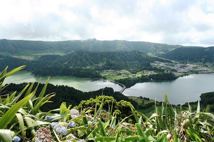
Situated 1,360 kilometres (850 mi) west of continental Portugal, about 880 kilometres (550 mi) northwest of Madeira and approximately 1,925 kilometres (1,196 mi) southeast of Newfoundland and Labrador, the Azores Geopark includes several geologically-significant sites throughout all nine islands and maritime seafloor of the Azores. There are 121 geosites in the nine islands, most of them with international or national relevance. The Geopark includes an area is 12,884 square kilometres (4,975 sq mi), including 2,324 square kilometres (897 sq mi) of subaquatic territory. Among these geosites, 57 were considered priority locations for the application of geoconservation strategies or for appreciation programs.
The archipelago of the Azores includes a rich and vast geodiversity, and an important geological patrimony, comprising various locales of interest to the scientific and pedagogical communities, in addition to its socio-economic importance to tourism. Due to it being an archipelago, the Azore Geopark is disperse: guaranteeing a representative geodiversity that characterizes the Azorean territory; manifesting in a history based on geological and active volcanism; with conservation strategies that are common; and based on a decentralized management structure with supports in all islands.
Characteristic of the Azorean geological history is a range of diverse features that includes (but is not limited to) volcanoes, calderas, lakes, lava fields, fumaroles, hot springs and thermal waters, volcanic caves, fajãs, fault scarps and marine fossil deposits. Beyond this heritage, there are other values of reference in the archipelago, such as its rich biodiversity, architecture, culture and ethnography.
Environmental awareness
The Geopark implemented various routes and trails on every island to discover the volcanic landscapes. Moreover, many educational activities are organized throughout the year to increase the environmental awareness.