
 | ||
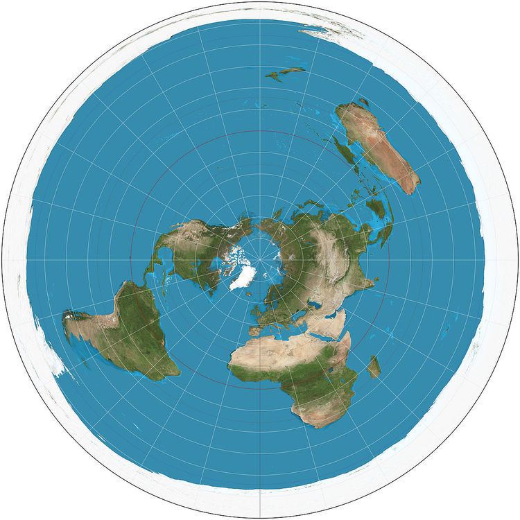
The azimuthal equidistant projection is an azimuthal map projection. It has the useful properties that all points on the map are at proportionately correct distances from the center point, and that all points on the map are at the correct azimuth (direction) from the center point. A useful application for this type of projection is a polar projection which shows all meridians (lines of longitude) as straight, with distances from the pole represented correctly. The flag of the United Nations contains an example of a polar azimuthal equidistant projection.
Contents
It is useful for showing airline distances from center point of projection and for seismic and radio work.
Distances and directions to all places are true only from the center point of projection. Distances are correct between points along straight lines through the center. All other distances are incorrect. Distortion of areas and shapes increases with distance from the center point.
History
While it may have been used by ancient Egyptians for star maps in some holy books, the earliest text describing the azimuthal equidistant projection is an 11th-century work by al-Biruni.
The projection appears in many Renaissance maps, and Gerardus Mercator used it for an inset of the north polar regions in sheet 13 and legend 6 of his well-known 1569 map. In France and Russia this projection is named "Postel projection" after Guillaume Postel, who used it for a map in 1581. Many modern star chart planispheres use the polar azimuthal equidistant projection.
Mathematical definition
A point on the globe is chosen to be special in the sense that mapped distances and azimuths from that point to any other point will be correct. That point, (φ1, λ0), will project to the center of a circular projection, with φ referring to latitude and λ referring to longitude. All points along a given azimuth will project along a straight line from the center, and the angle θ that line subtends from the vertical is the azimuth angle. The distance from the center point to another projected point is given as ρ. By this description, then, the point on the globe specified by (θ,ρ) will be projected to Cartesian coordinates:
The relationship between the coordinates (θ,ρ) of the point on the globe, and its latitude and longitude coordinates (φ, λ) is found as follows. The great circle distance ρ between two points (φ1, λ0) and (φ, λ) on the sphere is given by:
The azimuth from the first to the second point is given by:
When the center point is the north pole, these formulas greatly simplify to:
Applications
In the case of radio, this projection allows for directional antenna aiming, especially in the case of HF communications. An operator can point the antenna, usually by an electric rotator, simply locating the target in the map and rotating the antenna to the angle indicated by the map. The map should be centered as nearly as possible to the actual antenna location.