
Area 902.8 km² | ||
 | ||
Status Non-metropolitan district Points of interest Waddesdon Manor, Roald Dahl Children's Gallery, Buckinghamshire Railway Centre, Buckinghamshire County Museum, Wendover Woods Destinations | ||
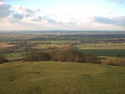
The Aylesbury Vale (or Vale of Aylesbury) is a large area of gently rolling agricultural landscape located in the northern half of Buckinghamshire, England. Its boundary is marked by Milton Keynes to the north, Leighton Buzzard and the Chiltern Hills to the east and south, Thame to the south and Bicester and Brackley to the west.
Contents
- Map of Aylesbury Vale District UK
- Aylesbury vale district council sdi16 awards
- Government
- Transport
- Tourism
- References
Map of Aylesbury Vale District, UK
The vale is named after Aylesbury, the county town of Buckinghamshire. Two other towns lie within the vale and they are Winslow and Buckingham.
The bed of the vale is largely made up of clay that was formed at the end of the ice age. Also at this time the vast underground reserves of water that make the water table in the Vale of Aylesbury higher than average, were created.
In the 2001 UK census the population of Aylesbury Vale was 165,748, representing an increase since 1991 of 18,600 people. About half of those live in the county town Aylesbury.
Aylesbury vale district council sdi16 awards
Government
Aylesbury Vale is a local government district of northern Buckinghamshire, administered by a district council. The district was formed on 1 April 1974 by the merger of the boroughs of Aylesbury and Buckingham, Aylesbury Rural District, Buckingham Rural District, Wing Rural District and part of Winslow Rural District. The district offices are based in Aylesbury. The district council's logo includes the historical figure of John Hampden.
There are 111 civil parishes: 84 with a parish council, including three town councils (Aylesbury, Buckingham and Winslow), and a further 27 operating with a Parish meeting, see list of civil parishes in Aylesbury Vale.
Elections to the district council take place every 4 years, with 59 councillors being elected from 36 wards. Since winning a majority at the 2003 election the Conservative party has held control of the council. After the latest election in 2015, it is composed of the following councillors:
Transport
The district contains no motorway junctions, although the M40 does enter the district for five miles between junctions 8A and 9. Major roads include the A41, A413 and A418- which all meet at Aylesbury. The A421 passes through the north of the district providing connections to Milton Keynes, Bedford and the M1 to the east, and the M40 and Oxford and Birmingham to the west.
For its size, the district contains relatively few railway stations; most of its stations are in the very south of the district along the London to Aylesbury Line- the major station being Aylesbury. At Aylesbury there are connecting services to Princes Risborough station. In addition, the West Coast and Chiltern main lines both pass through the district, each having a station within the district.
Tourism
The district has a number of historic buildings and landscapes which are popular tourist attractions. The National Trust owns several properties including Waddesdon Manor, Claydon House and the landscaped gardens at Stowe House. The Silverstone Circuit sits on the northern boundary of the district with South Northamptonshire, and the Buckinghamshire Railway Centre is located near Quainton.
Aylesbury is home to the County Museum (which includes the Roald Dahl Children's Gallery), and Buckingham features the Old Gaol Museum.