
Width 4,400 m (14,400 ft) Highest elevation 265.6 m (871.4 ft) Area 9.86 km² | Length 6,100 m (20,000 ft) Coastline 23,000 m (75,000 ft) Population 265 (June 2016) Elevation 266 m | |
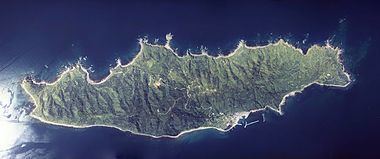 | ||
Awashima (粟島) is an island in the Sea of Japan . The island is located approximately 30 kilometres (19 mi) east of the city of Murakami in northern Niigata Prefecture.
Contents
- Map of Awashima Island Awashimaura Iwafune District Niigata Prefecture 958 0061 Japan
- History
- References
Map of Awashima Island, Awashimaura, Iwafune District, Niigata Prefecture 958-0061, Japan
Awashima is administratively the village of Awashimaura under Iwafune District of Niigata Prefecture. As of 2016, the island's population was 365.
History
Awashima has been inhabited since at least the Jomon period, as archaeologists have found Jomon period pottery shards in five locations on the islands east coast. However, no evidence of inhabitation from the Yayoi period or the Kofun period has yet been discovered. The name of the island first appears in a verse in the Nara period Man'yōshū poetry anthology, at which time the island was on the frontier of the Yamato state with the Emishi. The Matsura clan of northern Kyushu, noted pirates and sea traders, began to occupy the eastern shore of the island from the 9th century, gradually pushing the Emishi out. During the Edo period, the island passed between Murakami Domain, Shonai Domain and direct control by the Tokugawa Shogunate several times. During the Boshin War, the Schnell brothers offloaded weapons for Shonai Domain at Awashima. After the Meiji restoration, the village of Asahimaura was created in 1909 as part of Iwafune, District, Niigata Prefecture. The epicentre of the 1964 Niigata earthquake was near Awashima.