
Area 69,711 km² | Time zone CET (UTC+1) | |
 | ||
Departments 12 + 1 MetropolisAinAllierArdècheCantalDrômeHaute-LoireHaute-SavoieIsèreLoirePuy-de-DômeRhôneSavoieMetropolis of Lyon Colleges and Universities Jean Moulin University Lyon 3 Destinations Points of interest Alps, Courchevel, La Plagne, Les Arcs, Vercors Massif | ||
Annecy auvergne rh ne alpes france venice of the alps
Auvergne-Rhône-Alpes ([o.vɛʁɲ.ʁo.n‿alp], Arpitan: Ôvèrgne-Rôno-Ârpes, Occitan: Auvèrnhe-Ròse-Alpes) is a region of France created by the territorial reform of French Regions in 2014; it resulted from the merger of Auvergne and Rhône-Alpes. The new region came into effect on 1 January 2016, after the regional elections in December 2015.
Contents
- Annecy auvergne rh ne alpes france venice of the alps
- Map of Auvergne RhC3B4ne Alpes France
- Toponymy
- Geography
- Major communities
- References
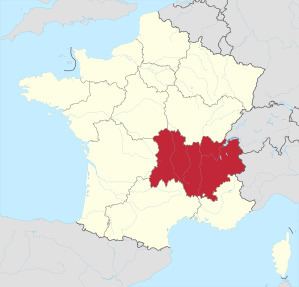
Map of Auvergne-Rh%C3%B4ne-Alpes, France
The region covers an area of more than 69,711 km2 (26,916 sq mi), making it the third largest in metropolitan France, with a population of 7,695,264, second only to Île-de-France.
Toponymy
The text of the territorial reform law gives interim names for most of the merged regions, combining the names of their constituent regions separated by hyphens. Permanent names would be proposed by the new regional councils and confirmed by the Conseil d'État by 1 October 2016.
The interim name of the new administrative region was a hyphenated placename, composed of the historic region of Auvergne + the river Rhône + the French Alps (Alpes). The same name has been chosen as the definitive name, which was officialized by the Conseil d'État on 28 September 2016.
Geography
The region borders Occitanie and Provence-Alpes-Côte d'Azur to the south, Bourgogne-Franche-Comté to the north, Nouvelle-Aquitaine to the west, Switzerland (Cantons of Geneva, Valais and Vaud) and Italy (Aosta Valley and Piedmont) to the northeast and east.