
Primary outflows Aura River Max. length 23 km (14 mi) Surface area 36.38 km (14.05 sq mi) Area 36.38 km² Width 2 km Primary outflow Aura | Max. width 2 km (1.2 mi) Surface elevation 856 m Length 23 km Year built 1953 | |
 | ||
Location Møre og Romsdal andOppland, Norway | ||
Aursj veien the aursj en road norway july 12th 2013 dashcam video
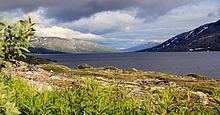
Aursjøen is a lake in Norway on the border between Lesja Municipality in Oppland county and Nesset Municipality in Møre og Romsdal county. The 36.38-square-kilometre (14.05 sq mi) lake sits at an elevation of 856 metres (2,808 ft) above sea level and is about 70.67 kilometres (43.91 mi) around.
Contents
- Aursj veien the aursj en road norway july 12th 2013 dashcam video
- Map of AursjC3B8en Norway
- References
Map of Aursj%C3%B8en, Norway
The lake was dammed up in 1953 to provide water for the Aura power station. It flooded together with the nearby lake Gautsjøen. The water in lake Aursjøen flows out to the river Aura which flows through the Eikesdalen valley and eventually to the lake Eikesdalsvatnet.
References
Aursjøen Wikipedia(Text) CC BY-SA