
Department Bas-Rhin Area 4.24 km² | Intercommunality Uffried Local time Wednesday 7:56 PM | |
 | ||
Weather 7°C, Wind S at 31 km/h, 83% Humidity | ||
Auenheim is a French commune in the Bas-Rhin department in the Grand Est region of north-eastern France.
Contents
- Map of 67480 Auenheim France
- Geography
- Toponymy
- Administration
- Demography
- Civil heritage
- The Maginot Line
- Religious heritage
- Notable people linked to the commune
- References
Map of 67480 Auenheim, France
The inhabitants of the commune are known as Auenheimois or Auenheimoises.
Geography
Auenheim is located some 15 km east of Haguenau and 13 km north-east of Bischwiller. Access to the commune is by the road D468 from Rœschwoog in the north-east which passes through the north of the commune and the village before continuing to Stattmatten in the south. The D463 branches off the D468 in the north of the commune and goes west to Rountzenheim. The TER Strasbourg-Lauterbourg railway passes through the village and there is a station in the commune which, however, appears to be disused. There is a belt of forest through the centre of the commune (the Biergrund) and a large forest in the south-east of the commune (the Unterwald) with substantial urbanisation in the north-west of the commune with the rest farmland.
The Moder river comes from the south and passes through the south-west then the centre of the commune before forming half of the eastern border and continuing east to join the Rhine at Neuhaeusel. There is also a large reservoir in the north of the commune.
Toponymy
According to the Cassini Map of 1750 Auen- was spelt Augenheim which in modern German would mean "of the eye" + -heim meaning "hamlet or village".
The suffix -heim indicates a Frankish origin since before the first creation of villages by the Alemanni. -heim signified a "hamlet" or a group of houses in French from which came the Alemannic hüs from which comes haus which is "house" in German.
In 1359 the village was called Oweheim and in 1596 it was Awenheim.
Administration
List of Successive Mayors
(Not all data is known)
Demography
In 2010 the commune had 872 inhabitants. The evolution of the number of inhabitants is known from the population censuses conducted in the commune since 1793. From the 21st century, a census of communes with fewer than 10,000 inhabitants is held every five years, unlike larger towns that have a sample survey every year.
Sources : Ldh/EHESS/Cassini until 1962, INSEE database from 1968 (population without double counting and municipal population from 2006)
Civil heritage
The commune has a number of buildings and sites that are registered as historical monuments:
One structure is registered as an historical object:
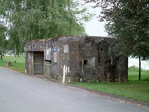
The Maginot Line
An isolated infantry Blockhouse, simple flank built in 1932. It housed an officer, a non-commissioned officer and 20 enlisted men.
An isolated infantry Blockhouse, simple flank built in 1932. It housed an officer, a non-commissioned officer and 20 enlisted men.
Religious heritage
The commune has one religious site that is registered as a historical monument: