
Area 11.31 km² Local time Wednesday 7:43 PM | Region Normandy Intercommunality Val de Seulles Population 839 (1999) | |
 | ||
Weather 9°C, Wind W at 39 km/h, 79% Humidity | ||
Audrieu is a French commune in the Calvados department in the Normandy region of north-western France.
Contents
- Map of 14250 Audrieu France
- Geography
- History
- Administration
- Demography
- Civil heritage
- Religious heritage
- Notable people linked to the commune
- References
Map of 14250 Audrieu, France
The inhabitants of the commune are known as Aldériens or Aldériennes.
Geography
Audrieu is located some 11 km south-east of Bayeux and 16 km west by north-west of Caen. Access to the commune is by the D 82 road from Ducy-Sainte-Marguerite in the north which passes south through the centre of the commune and the village and continues to Tilly-sur-Seulles in the south. The D 187 branches off the D 82 in the north of the commune and goes west to Chouain. The D 178 branches off the D82 south of the village and goes west to Juaye-Mondaye. The D158 branches off the D 82 in the north of the commune and goes north to Loucelles. The D 94 branches of the D 82 in the village and goes east to Brouay. The railway from Bayeux to Caen passes through the north of the commune with a station at Le Haut des Jardins. Apart from the village there are the hamlets of Lieu Moussard, Hervieu, Le Haut des Jardins, Le Bas d'Audrieu, Le Calvaire, Ferme de la Motte, Hameau Pavie, and Le Pont Roch. The commune is farmland with residential areas mostly along the D 82.
The Seulles river forms the western border of the commune as it flows north to join the ocean at Courseulles-sur-Mer.
History
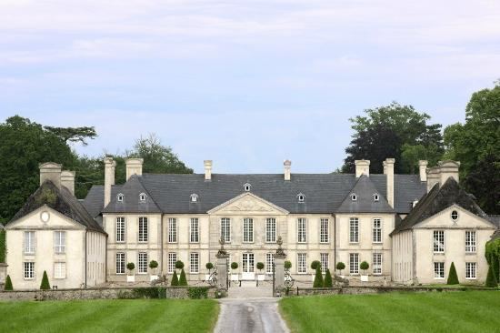
Audrieu village dates back to Classical Antiquity when it was called Alderium. There are traces of Gallo-Roman dwellings and a Motte-and-bailey castle. The first lord of the area was Percy, cook for William the Conqueror, who gave it to the descendants of the Duke of Northumberland. In 1593 Audrieu returned to Guillaume de Séran, who married Marguerite de Percy, and whose lordship became a barony in 1615.
After being sold in the French Revolution the château returned to the Séran family at the Restoration and is still in the hands of their descendants. During the Second World War Gerhard Bremer, commandant of the 12th Reconnaissance Battalion of the German army established his headquarters in the château. On 8 June 1944, in clearings, forests, and orchards surrounding the castle, 24 members of the 3rd Canadian Infantry Division were executed: 22 from the Royal Winnipeg Rifles and two from the Queen's Own Rifles of Canada. Two British soldiers were killed at the same time. The castle now houses a luxury hotel and restaurant.
Administration
List of Successive Mayors
(Not all data is known)
Demography
In 2010 the commune had 1,042 inhabitants. The evolution of the number of inhabitants is known from the population censuses conducted in the commune since 1793. From the 21st century, a census of communes with fewer than 10,000 inhabitants is held every five years, unlike larger towns that have a sample survey every year.
Sources : Ldh/EHESS/Cassini until 1962, INSEE database from 1968 (population without double counting and municipal population from 2006)
Civil heritage
The commune has two buildings and sites that are registered as historical monuments:
Other sites of interest are:
Religious heritage
The commune has one religious buildings that is registered as a historical monument:
The Church contains three items that are registered as historical objects: