
Length 143 km Country United States of America | Mouth elevation 0 | |
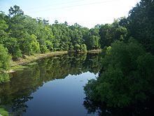 | ||
The Aucilla River rises close to Thomasville, Georgia, USA, and passes through the Big Bend region of Florida, emptying into the Gulf of Mexico at Apalachee Bay. Some early maps have it called the Ocilla River. The river is 89 miles (143 km) long and has a drainage basin of 747 square miles (1,930 km2). The Wacissa River is a tributary. In Florida, the Aucilla River forms the eastern border of Jefferson County, separating it from Madison County on the northern part, and from Taylor County to the south. The lower part of the river disappears underground and reappears several times, and is known as the Aucilla River Sinks. The Aucilla River is a rich source of late Pleistocene and early Holocene animal bones and human artifacts, and is the subject of the Aucilla River Prehistory Project, which includes the Page-Ladson prehistory site. During the first Spanish period in Florida the Aucilla River was the boundary between the Apalachee people and the Timucua-speaking Yustaga (or Uzachile) people.
Contents
Map of Aucilla River, Florida, USA
Near Boston, Georgia the Aucilla River temporarily becomes a subterranean river at Howell Sinks.