
 | ||
The Atlantic Seaboard Fall Line, or Fall Zone, is a 900-mile (1,400 km) escarpment where the Piedmont and Atlantic coastal plain meet in the eastern United States. Much of the Atlantic Seaboard fall line passes through areas where no evidence of faulting is present.
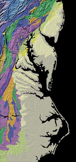
The fall line marks the geologic boundary of hard metamorphosed terrain—the product of the Taconic orogeny—and the sandy, relatively flat outwash plain of the upper continental shelf, formed of unconsolidated Cretaceous and Cenozoic sediments. Examples of the Fall Zone include the Potomac River's Little Falls and the rapids in Richmond, Virginia, where the James River falls across a series of rapids down to its own tidal estuary.
Before navigation improvements such as locks, the fall line was generally the head of navigation on rivers due to their rapids or waterfalls, and the necessary portage around them. The Little Falls of the Potomac River is one example. Because of the commercial traffic, required labor and availability of water power to operate mills, numerous cities were founded at the intersection of rivers and the fall line. U.S. Route 1 links many of the fall line cities.
In 1808, Treasury Secretary Albert Gallatin noted the significance of the fall line as an obstacle to improved national communication and commerce between the Atlantic seaboard and the western river systems:
The most prominent, though not perhaps the most insuperable obstacle in the navigation of the Atlantic rivers, consists in their lower falls, which are ascribed to a presumed continuous granite ridge, rising about one hundred and thirty feet above tide water. That ridge from New York to James River inclusively arrests the ascent of the tide; the falls of every river within that space being precisely at the head of the tide; pursuing thence southwardly a direction nearly parallel to the mountains, it recedes from the sea, leaving in each southern river an extent of good navigation between the tide and the falls. Other falls of less magnitude are found at the gaps of the Blue Ridge, through which the rivers have forced their passage...
Notable cities
Some cities that lie along the Piedmont—Coastal Plain fall line include the following (from north to south):