
Intercommunality Vallée et du Causse Area 16.49 km² | Region Occitanie Population (2010) 684 Local time Monday 1:16 AM | |
 | ||
Weather 5°C, Wind NE at 0 km/h, 90% Humidity | ||
Assier dame tu veneno video lyric oficial eurovisi n 2017
Assier is a French commune in the Lot department in the Occitanie region of south-western France.
Contents
- Assier dame tu veneno video lyric oficial eurovisi n 2017
- Map of 46320 Assier France
- Assier coraz n herido videoclip oficial
- Location and access
- Relief
- Geology
- Hydro geology
- Potholing
- Toponymy
- Prehistory
- The Fortified Town
- The Commandery of Assier
- The Hundred Years War
- The Lords of Assier
- The French revolution in Assier
- The first schools
- Fight against poverty
- Technical progress
- Administration
- Demography
- Agriculture
- Trades services and crafts
- Industrial area
- Civil heritage
- Religious heritage
- Education
- Associations
- Public services
- Health
- Notable people linked to the commune
- References
Map of 46320 Assier, France
The inhabitants of the commune are known as Assiérois or Assiéroises.
Assier coraz n herido videoclip oficial
Location and access
Assier is located some 12 km north-west of Figeac and some 18 km south-east of Gramat. The village is in the centre of the commune at the intersection of two highways: the D11 from Saint-Simon in the north-west which continues to Reyrevignes in the south-east and the D653 from Livernon in the south-west which continues to join the D840 north-east of the commune.
The Brive-la-Gaillarde to Rodez railway passes through the commune from north-west to south-east with a station just west of the village.
Relief
The highest parts of the commune are to the north-east (about 400 metres above sea level). The Limargue landscape provides grazing for cattle. A small stream flows with a slight slope parallel to the D653 in a wide valley flooded during heavy rain. After two ponds and an old mill, its water is lost near the centre of the village (altitude 350 metres).
In the south the rocky terrain forms a slightly undulating limestone plateau (320–330 metres above sea level) pierced by a few sinkholes around ten metres deep. This plateau is covered with short grass (dry grasslands) which supports flocks of sheep. There are also forests of contorted downy oaks that are used for firewood.
Geology
Assier is located at the end of an Early Jurassic formation called Limargue at the edge of the Causses limestone.
In the south-east the Causse de Gramat is composed of Karstified limestone from the Middle and Late Jurassic.
The oldest Early Jurassic terrain is in the Ruisseau d'Assier to the north-west:
The valley floor consists of alluvium brought down by modern streams.
Hydro-geology
Assier is on the edge of the Causse de Gramat. The waters from the Limargue to the north-east come across impermeable marl from the Early Jurassic the descend below the permeable limestone from the Middle and Late Jurassic. The limit of the Drainage basin is located to the north of Assier, water flows towards the south towards the Célé: this is the system called "Gramat-Sud" which drains 330 square kilometres.
To the north-west, north of Vialans, there are the emergences of Routabous and Tour de Maroc of calcareous sandstone from the Pliensbachian period.
The small streams or Biales sink into the limestone through karstic openings. From north-west to south-east, these are:.
Previously, other cavities at a higher altitude would have been of old sinkholes or were connected to the existing water systems: the Grotte du Cirque and the Grotte du Fennet.
Potholing
In addition to the sinkholes in the Limargue-Causse contact zone, many caves and Pit caves open up on limestone terrain. The best known are:
Toponymy
The name Assier could be related to the name of a watercourse according to Ernest Nègre. According to others Assier has a Germanic origin after a person called Anshari. This name decomposes to: ans, a pagan deity, and hari meaning "army".
Prehistory
The territory of Assier has been inhabited from the earliest times. Three dolmens and tumuli are visible on the limestone of the plateau to the east of the village.
The dolmens around Assier were made from thick strata of limestone. They are located on the Causse de Gramat and were emptied of their contents in the past.
Four other dolmens and a menhir were also present north-west of the village in the hamlet of Mons at a place called Le champ de Belair. At least two of these dolmens are still visible today. The menhir was removed in the past but was returned flat near its original location by the landowner.
The Fortified Town
In the Middle Ages Assier had the appearance of a fortified camp: a village surrounded by a defensive wall. Of the first feudal castle only the Tour de Sal (Sal Tower) remains. Outside the walls there were extended suburbs called barry: barry de Mons, barry des Sal, barry de las botas, barry des leygue, and barry del Torria. Assier had the Abbot of Figeac as their Lord and it was attached to the Order of St. John of Jerusalem though some hamlets such as Vialan depended on the Hospital of Issendolus.
From the 13th century the Assier community had the right to elect consuls. Every year on the first Sunday of September, all heads of household paid tax to one or more elected consuls.
The Commandery of Assier
Around 1280, the Knights of the Order of St. John of Jerusalem founded a commandery. It was a donation by Barasc who owned part of the lordship of Assier. It included: a fortified house, a church dedicated to St. Peter, a hospital on the site of the Chateau of Galiot de Genouillace, a leprosarium at a place called Malaudie on the road to Reyrevignes.
List of Knights and Priests of the Order of St. John of Jerusalem who were tax collectors in Assier:
The Hundred Years War
From 1355, the entire Quercy region became a theatre of struggle during the Hundred Years War. The Black Prince and his English troops invaded the south-west and Quercy. After the French defeat at the Battle of Poitiers, the Treaty of Brétigny gave England the Guyenne and Gascony. The region was unstable because all the lords did not rally to the King of England.
Armed gangs were active for the English or on their own account. They robbed, ransomed, and massacred the population. One of these bands, under the orders of Bassorat, had their hideout at the Tour de Marot or the Tour de Maroc at a place called La Garénie. Bassorat ravaged the country until 1395 when he left for Spain. The English left the region around 1450.
Assier and its surroundings were ruined, it had to repopulate the country by bringing families from Auvergne, Rouergue, and elsewhere by providing favourable conditions. During this calmer period of 1450–1547 the church and the chateau were built. Many workers and tradesmen came and agriculture grew.
The Lords of Assier
From the 12th century the first lords mentioned were called the Rigaud d'Assier. One member of this family was pastor of Toulouse Cathedral and lived at the court of Pope John XXII. Some of his guests at his house in Avignon were involved in the 1317 plot against the Pope He was Bishop of Winchester from 1319 to 1323.
Raymond du Bosc, Lord of La Garénie became co-lord of Assier by marrying a Rigaud: Marguerite of Assier. One of his descendants, Augé du Bosc married Jeanne de Rassiols in 1439, Lady of Vaillac. Their daughter Catherine of Assier married Jean Ricard de Ginouillac in 1464. From their union Jacques Ricard Genouillace called Galiot de Genouillace was born in 1465 at the Chateau of Assier who had a brilliant military and diplomatic career. After his death in 1546 his body was repatriated and buried in a chapel of the Church of Assier in 1549. After the death of his son François in 1544 at the Battle of Cérisoles, his daughter Jeanne became his sole heir. She married Charles de Crussols d'Uzes, 9th Viscount of Uzes, in 1523. Widowed in 1543, she remarried the Palatine Prince Philip de Saim called Rhinegrave and converted to the Protestant religion. Their son, Jean de Beaudiné, was invited to the wedding of the future Henry IV and was killed in 1572 during the St. Bartholomew's Day massacre. Twenty years of turmoil shook the region. After the Edict of Nantes, Figeac, Cardaillac, and Assier were governed by the Protestants for 50 years.
Jacques de Crussol, heir to Jeanne Ricard de Ginouillac, converted to Catholicism. He was named duke and peer of France. In 1768 the 9th Duke of Uzes, François Emmanuel Crussol, sold the chateau to be demolished. The chateau and the lands left the founding family. The new co-lords of Assier were, until the French revolution, Messrs Pouzalgue, Séguy, and Montal.
The French revolution in Assier
On 14 September 1788 Jean-Pierre Séguy, notary, bought the land of the Devèze d'Assier and became a co-lord of Assier. The French revolution passed without major disorder: the main complaints concerned the redistribution of land. Jean-Pierre Séguy redistributed land he had bought to all the inhabitants of Assier present and future (from pregnant women) who each received 0.34 hectares. He was mayor of the commune from 1801 to 1827.
The first schools
Following the Guizot law communes had to have a public school. On 21 December 1834 the council appointed Jean-Pierre Bruel to run the school. He received two hundred francs per year as well as sums paid by the wealthiest families for the education of their children: 1 franc to learn to read, 1 franc 50 centimes for reading and writing, and 2 francs for mathematics. Twelve poor students were taught without charge.
In 1853, a free school for girls was headed by Marie Bessac (Sister Victoire) assisted by Jeanne Turenne (Sister Jeanne). They were paid by the commune. On 25 October 1858 Jean-Pierre Bruel died and Jean Delsériez succeeded him in 1859. In 1881 an assistant position was created as numbers then were 75 boys and 60 girls. A nursery for infants was created next to the girls' school: the cost was 1.5 francs per student per month. The position is given to Sister Jeanne Turenne. On 20 August the position of assistant to the boys' school was created.
In 1902 a secular girls' school opened. In 1905 schooling was compulsory and free for all children over five years. In 1926, the municipal council protested against the abolition of the post of Assistant for the Public School. In 1957 construction began on a new school for Assier.
Fight against poverty
During the mandates of Antoine Pezet and Joseph Carbonel from 1848 to 1870 many decisions were taken to improve the lot of the poorest:
Technical progress
The railway
In 1854 two rail projects passing through Assier were considered then abandoned. A Classification yard was to have been located in the commune and there were plans to build a hotel-restaurant with 16 rooms near the proposed route of the line. This is the large isolated house at a place called Frejayrie, one kilometre from the centre of Assier.
In 1860, the Compagnie du chemin de fer de Paris à Orléans started building the Brive-Rodez line passing through Assier station. Four fatal accidents occurred in the commune which killed a navvy and three workers. The line was opened in September 1862.
Other modes of travel
In 1905 and 1910 tramway projects were considered to serve Assier station and neighbouring communes: a line from Gourdon to Le Bourg via Quissac and Espédaillac. Soon, however, the car made its appearance. In 1923 the Municipal Council was required to limit the speed of cars to less than 15 km/h in the town centre. In 1925 the widow of Thimoté Gardou installed the first petrol pump and the commune received 200 francs per year. In 1932 buses ran between Assier and Cahors.
Electrification
On 11 October 1922 the council appointed a commission to study the connection of the village to a power grid. On 9 May 1926 appropriations for the establishment of a union for electrification were voted. On 30 October the mayors of Cardaillac, Fourmagnac, Fons, Reyrevignes, and Assier met and decided that the electric current should be supplied by the hydro-electric plant of Mr. Barrière located on the Drauzou but in 1927 the council denounced the agreement with Mr. Barrière on the grounds that his plant could not supply power permanently because the flow of the Drauzou was too irregular. In 1928 the commune had to pay a 225,000 franc fine for non-compliance with the agreement but appealed and was successful in 1932.
The commune then joined the electrification union of the north of Lot and, in 1930, the concession was given to the Bourbonnais company. The contract was signed on 19 February 1931 and on 17 April 1932 there was the inauguration and celebration of the electricity supply.
In the village the telephone and electricity lines have been buried since 1980.
Access to water
Prior to 1962, the inhabitants of Assier accessed water through fountains or cisterns. There were shortages and supply was a constant concern of councils:
Administration
List of Successive Mayors
(Not all data is known)
Demography
In 1620 there were 115 fires in Assier. In 1750 there were 500 communicants at Mass.
In 2010 the commune had 684 inhabitants. The evolution of the number of inhabitants is known from the population censuses conducted in the commune since 1793. From the 21st century, a census of communes with fewer than 10,000 inhabitants is held every five years, unlike larger towns that have a sample survey every year.
Sources : Ldh/EHESS/Cassini until 1962, INSEE database from 1968 (population without double counting and municipal population from 2006)
Agriculture
Assier is a rural community which had a dozen farms at the end of the 20th century. Operators abandoned polyculture (cereals and fruit trees) to turn to the production of meat and milk. 95% of the Limargue land is exploited, 20% of the land on the plateau is for sheep while the remaining 80% is left fallow.
Fairs were very important up to the 19th century and equalled those of Figeac and Gramat. A market hall was built in 1884 for the sale of cereals, chestnuts, apples and nuts. These products declined in the 20th century as a result of evolution in transport, the mechanisation of farms, and trading by the farmer. Since 1968 the council has taken steps to revive the market for sheep. In 1980 studies were carried out for the implementation of a covered sheep market which was inaugurated in July 1997 in the industrial zone. It trades between 1,500 and 2,000 animals every Monday.
Assier has a cattle market and an agricultural cooperative.
Trades, services, and crafts
Many shops and services are available on the town: butchers, bakers, a Pâtisserie, a bar, hairdressers, restaurants, a florist, and a grocery store; as well as tradesmen: roofers, carpenters, electricians, plumbers, heating, and a taxi.
A pharmacy is located in the town centre.
Industrial area
A company making high quality walnut veneers is established in the industrial zone.
The cooperative society Scop O'Chêne was established at Assier as part of its expansion. It manufactures building frames: structures used as assembly modules, and wood furnishings. It had 7 employees in 2009.
Civil heritage
Assier has a number of buildings and structures that are registered as historical monuments:
The Chateau contains a number of items that are registered as historical objects:
Religious heritage
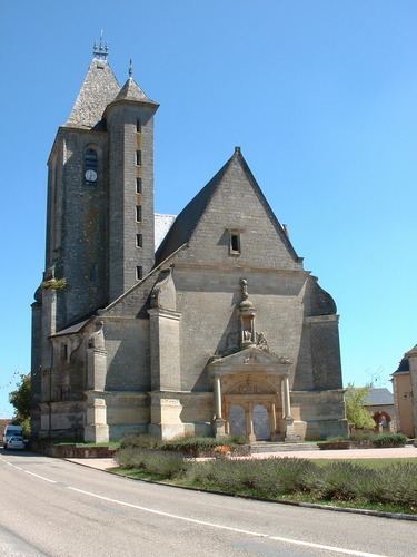
The Church of Saint-Pierre is the only Renaissance religious building in Lot. Begun in 1540 and completed in 1549 the church is in monumental style and solely dedicated to the glory of Galiot de Genouillace with his reclining statue and the epitaph "After death, good name remains".
An outer frieze in low relief surrounds the monument. This profane and warlike decoration is unusual on a religious building. Galiot de Genouillace saw the church as a monument housing his tomb and that of his descendants. The grounds evoke scenes of war with Italy in the passage through the Alps before the victory of the Battle of Marignano.
Jean Bergue remarked in his 1987 study that this artistic and historical masterpiece has visibly deteriorated over a hundred years.
The sculptural elements represent the triumph of the artillery with the cannon the most widespread theme namely: the Culverin bastard, palace sieges, round shot with three flames, ancillary parts of a very high precision that make this frieze a true archival document on the art of war at the time with no equivalent.
There are swords with a Fleur-de-lis Baldric recalling the charge by the Grand Squire of France next to the collar of the Order of St. Michael which was the highest distinction of the time.
There is a Funeral Chapel north of the first bay of the nave. It contains the tomb of Galiot de Genouillace who is represented on the marble reclining statue in court dress and then in armour leaning on a cannon and surrounded by bullets and bags of gunpowder.
The vault of this chapel is quite remarkable and unique in France: there is only one other example of this architecture in Europe - the monastery of San Domingo at Valencia in Spain. Both have a vault and a dome with triple ribs and Lunettes which give the impression of a star with a complicated design or a huge spiderweb canvas in which it is thought the final cut to size of some stones was performed after laying.
The Church of Saint Pierre contains three items which are registered as historical objects:
Education
The Assier school enrols children from eleven neighbouring communes. In September 2009, the nursery school had two classes and the primary school three. The staff consists of seven teachers and two assistants.
Associations
A festival of jazz, improvisation, and theatre has taken place every year since 1986 in the chateau, the church, the gardens, and in the squares.
The REISSA Association (Meetings, Events, Initiatives, Support, Social Activities) manages the events in the village and the ALSH (Home Leisure Without Accommodation) for children.
The Cyber-base located in the House of services provides access to the Internet for all.
Public services
Assier has a post office, a railway station, and a public weighbridge near the fairgrounds in the direction of Livernon.
Health
In 2009 Assier inaugurated the Causse Medical Centre. The town also has a pharmacy and a nursing centre in the village centre.
A nursing home for the elderly is located at Les Pradels.
The nearest hospitals are located at Figeac (21 km, 20 minutes by the D653 and D840) and at Cahors (57 km, 52 minutes by the D653).