
Length 75 km | Basin size 500 km (190 sq mi) Basin area 500 km² | |
 | ||
Main source Tartonne1,350 m (4,430 ft) River mouth Durance320 m (1,050 ft) Discharge Average rate:5 m/s (180 cu ft/s) | ||
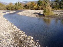
The Asse (Assa in Occitan) is a 75.4-kilometre (46.9 mi) long river in the Alpes-de-Haute-Provence département, southeastern France. Its source is several small streams which converge at Tartonne, 12 kilometres (7 mi) east of Digne-les-Bains. It flows generally southwest. It is a left tributary of the Durance into which it flows between Valensole and Oraison, 9 kilometres (6 mi) northeast of Manosque.
The Asse is called "Asse de Clumanc" between its source and its confluence with the "Asse de Blieux" and the "Asse de Moriez" at Barrême.
Part of its valley is used by the route Napoléon.
Communes along its courseEdit
This list is ordered from source to mouth: Tartonne, Clumanc, Saint-Lions, Barrême, Chaudon-Norante, Beynes, Entrages, Châteauredon, Mézel, Estoublon, Bras-d'Asse, Saint-Julien-d'Asse, Brunet, Le Castellet, Valensole, Oraison