
Architect Olmsted Bros.; Et al. Area 76 ha | NRHP Reference # 86000755 Added to NRHP 31 March 1986 | |
 | ||
Location Roughly bounded by Ashland Ave., Richmond Rd., Chinoe Rd., and Fontaine Rd., Lexington, Kentucky Architectural style Colonial Revival, Bungalow/craftsman, Other, American Foursquare | ||
Lexington ky neighborhood tour by the lexpert ashland park chevy chase
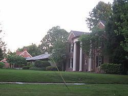
Ashland Park is a historic early 20th century neighborhood in Lexington, Kentucky, United States. It was named after Ashland, the estate of Kentucky statesman Henry Clay which is located in the eastern portion of the neighborhood. The 600-acre (2.4 km2) development was designed by the famous landscape architecture firm the Olmsted Brothers of Massachusetts. The neighborhood belongs to the National Register of Historic Places.
Contents
- Lexington ky neighborhood tour by the lexpert ashland park chevy chase
- Map of Ashland Park Lexington KY 40502 USA
- References
Map of Ashland Park, Lexington, KY 40502, USA
Prominent architectural styles of houses and apartment buildings in the neighborhood include American Foursquare, American Craftsman, Colonial Revival, and Tudor Revival.
The neighborhood's boundaries are Ashland Avenue to the west, East Main Street (U.S. Route 25) to the north, Chinoe Road to the east, and Fontaine Road to the south. The commercial district of Chevy Chase borders Ashland Park on the south. In 2000 the population was 1,864.