
 | ||
Points of interest Tanzawa Mountains, Mount Tanzawa, Shasui Falls, Lake Tanzawa, Mount Hiru | ||
Ashigarakami District (足柄上郡, Ashigarakami-gun) is a district located in western Kanagawa Prefecture, Japan. Most of the mountainous district is sparsely populated, and is part of the Tanzawa-Ōyama Quasi-National Park. Parts of the cities of Hadano and Odawara, and the entire city of Minamiashigara were formerly part of Ashigarakami District.
Contents
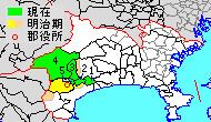
Map of Ashigarakami District, Kanagawa Prefecture, Japan
As of 2009, the district had an estimated population of 67,954 and a density of 224 persons per km². The total area was 303.44 km².
Towns and villages
History
Ashigarakami District was one of the ancient subdivisions of Sagami Province, per the Nara period Ritsuryō system, under the name as Ashinokami District (足上郡, Ashinokami-gun). The area was under control of the late Hōjō clan in the Sengoku period, and part of Odawara Domain during the Edo period. Following disasters caused by eruptions of nearby Mount Fuji, a portion also came to be held as tenryō territory administered by the Tokugawa shogunate.
Timeline
After the Meiji Restoration, it initially formed part of the short-lived Ashigari Prefecture, before was established as a district of Kanagawa Prefecture under the cadastral reform of 1878. In 1889, it was administratively divided into 26 villages.
On April 1, 1972, part of Ashigarakami District became the city of Minamiashigara.