Area 20.02 km² Local time Monday 2:08 PM | Region Kantō Population 9,871 (1 Jun 2012) | |
 | ||
- Flower Platycodon grandiflorus Weather 15°C, Wind SE at 14 km/h, 57% Humidity | ||
Nakai (中井町, Nakai-machi) is a town located in Ashigarakami District, Kanagawa Prefecture, Japan. As of June 2012, the town had an estimated population of 9,871 and a population density of 493 persons per km². The total area was 20.02 km².
Contents
- Map of Nakai Ashigarakami District Kanagawa Prefecture Japan
- Geography
- Surrounding municipalities
- History
- Economy
- Transportation
- Noted People from Nakai
- References
Map of Nakai, Ashigarakami District, Kanagawa Prefecture, Japan
Geography
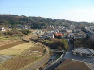
Nakai is located in the hills of western Kanagawa Prefecture.
Surrounding municipalities
History
During the Edo period, the area around present-day Nakai was part of Odawara Domain in Sagami Province. After the Meiji Restoration, it became part of Ashigarakami District in Kanagawa Prefecture. Nakai village was formed on April 1, 1889. It merged with neighboring Iguchi village on April 1, 1908. The village was elevated to town status on December 1, 1958.
Economy
The town economy is primarily agricultural, with dairy farming, mandarin oranges predominating. An industrial zone established near the Tōmei Expressway has attracted a number of industries, including Fuji Xerox, Terumo and Nippon Express.
Transportation
Nakai has no train service, and is not on a national highway, although the Tōmei Expressway bisects the town. Nakai can be reached by Kanagawa Prefectural Route 71 or 77.
