
Intercommunality Miey de Béarn Area 10.74 km² | Time zone CET (UTC+1) Population 1,441 (2006) | |
 | ||
Artiguelouve is a French commune in the Pyrénées-Atlantiques department in the Nouvelle-Aquitaine region of south-western France.
Contents
- Map of 64230 Artiguelouve France
- Geography
- Toponymy
- History
- Administration
- Inter communality
- Demography
- Economy
- Religious heritage
- Education
- Sports and Sports facilities
- Notable people linked to the commune
- References
Map of 64230 Artiguelouve, France
The inhabitants of the commune are known as Artiguelouviens or Artiguelouviennes.
Geography
Artiguelouve is located in the urban area of Pau some 8 km north-west of Pau and 3 km south-west of Lescar. Access to the commune is by road D2 from Laroin in the south-east passing through the north-east of the commune and continuing north-west to Pardies. The D509 connects the D2 to the D817 across the river. The D804 branches off the D2 in the commune and goes west along the northern fringe of the town and continues to Arbus. Access to the centre of the town is by the D146 which branches off the D804 and goes south through the town and continues to Aubertin. The residential area of the town occupies about 10% of the commune with the rest mixed forest and farmland.
Bus Route 802 from Artix to Pau of the Interurban network of Pyrénées-Atlantiques has a stop in the commune.
The Gave de Pau runs along the north-eastern border of the commune and passes through the north of the commune flowing north-west. The Juscle river flows from the south of the commune to near the town then flows north-west parallel to the Gave de Pau until it eventually joins the Gave de Pau near Tarsacq.
Toponymy
Artiguelouve (meaning "clearing of wolves" in the béarnaise definition), comes from 'artiga which means "clearing" or "fallow land" and the oronym lob ("height").
The following table details the origins of the commune name and other names in the commune.
Sources:
Origins:
History
Paul Raymond noted on page 14 of his 1863 dictionary that, in 1385, Artiguelouve had 28 fires and depended on the bailiwick of Pau. The commune was a dependency of the Marquisate of Gassion and, with Poey, formed the jurisdiction of a notary.
Administration
List of Successive Mayors
(Not all data is known)
Inter-communality
The commune is part of seven inter-communal structures:
Demography
In 2010 the commune had 1,544 inhabitants. The evolution of the number of inhabitants is known from the population censuses conducted in the commune since 1793. From the 21st century, a census of communes with fewer than 10,000 inhabitants is held every five years, unlike larger towns that have a sample survey every year.
Sources : Ldh/EHESS/Cassini until 1962, INSEE database from 1968 (population without double counting and municipal population from 2006)
Economy
The commune is part of the Appellation d'origine contrôlée (AOC) zones of Jurançon AOC, Béarn AOC, and Ossau-iraty.
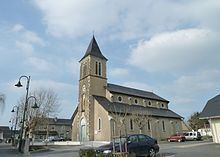
Religious heritage
The Church of Saint-Michel (15th century) is registered as a historical monument.
Education
The commune has a school grouping consisting of two kindergarten classes and five primary school class (Marc Dugène School Group) as well as a library / media centre.
Sports and Sports facilities
The Artiguelouve Golf Course and also that of Billère are the two golf courses in the Pau area. La Maison des sports was opened on 29 May 2010.
Le FC3A is a football club and school for players from Artiguelouve, Arbus, and Aubertin.