
Intercommunality Miey de Béarn Area 13.89 km² | Canton Lescar Time zone CET (UTC+1) Population 1,031 (1999) | |
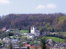 | ||
Arbus (Arbús in Occitan) is a French commune in the Pyrénées-Atlantiques department in the Nouvelle-Aquitaine region of southwestern France.
Contents
- Map of 64230 Arbus France
- Geography
- Toponymy
- History
- Administration
- Inter communality
- Demography
- Economy
- Religious Heritage
- Education
- Notable people linked to the commune
- References
Map of 64230 Arbus, France
The inhabitants of the commune are known as Arbusiens or Arbusiennes
Geography
Arbus is located in the urban area of Pau 15 km to the north-west of the city and some 35 km south-east of Orthez mostly on the south bank of the Gave de Pau. Access to the commune is on the D2 road from Laroin in the south-east passing through the north of the commune to Abos in the north-west. Access to the village is by the D804 running off the D2 in the commune and continuing to Artiguelouve in the south-east and also by the D229 from the village to Parbayse in the south-west. The commune is mixed forest and farmland with large forests in the west, south, and south-east.
Located in the Drainage basin of the Adour, the Gave de Pau flows through the northern part of the commune with some of its tributaries flowing through the rest of the commune: the Juscle and Baise Lasseube, as well as their tributaries, the Sibé stream, and the old Canal du Moulin which is itself joined in the commune by the Arrious stream.
Toponymy
The commune name in béarnais is Arbús (according to the classical norm of Occitan). According to Michel Grosclaude, there is an aquitane root *arb-, meaning "grass" (close to alpe), and a collective suffix -untz giving a meaning of "a place where there is grass".
The following table details the origins of the commune name and other names in the commune.
Sources:
Origins:
History
Paul Raymond on page 5 of his 1863 dictionary noted that in 1385 Arbus had 40 fires and depended on the bailiwick of Pau. The town was a dependency of the Marquisate of Gassion.
Administration
List of Successive Mayors
(Not all data is known)
Inter-communality
The commune of Arbus is part of eight inter-communal structures:
Demography
In 2009 the commune had 1,098 inhabitants. The evolution of the number of inhabitants is known from the population censuses conducted in the commune since 1793. From the 21st century, a census of communes with fewer than 10,000 inhabitants is held every five years, unlike larger towns that have a sample survey every year.
Sources : Ldh/EHESS/Cassini until 1962, INSEE database from 1968 (population without double counting and municipal population from 2006)
Economy
The commune is part of the Appellation d'origine contrôlée (AOC) zone of Winemakers of Jurançon and of Béarn and partially in the AOC zone for Ossau-iraty.
Religious Heritage
The Parish Church of Saint-Mamer (1868) is registered as an historical monument.
Education
The town has a primary school.