Department Ain Area 5.5 km² Local time Thursday 2:41 AM | Canton Reyrieux Time zone CET (UTC+1) Population 1,102 (1999) | |
 | ||
Weather 9°C, Wind S at 16 km/h, 75% Humidity | ||
Ars-sur-Formans is a French commune in the Ain department in the Auvergne-Rhône-Alpes region of eastern France.
Contents
- Map of 01480 Ars sur Formans France
- Geography
- Toponymy
- History
- Administration
- Twinning
- Demography
- Civil heritage
- Religious heritage
- Religious communities
- Events
- Notable people linked to the commune
- References
Map of 01480 Ars-sur-Formans, France
The inhabitants of the commune are known as Arsois or Arsoises
Geography
The village is in the south-western part of the Ain department 33 km north of Lyon and 10 km east of Villefranche-sur-Saône in the heart of the Dombes region - known for its many lagoons. Ars-sur-Formans is on the Dombes plateau while to the west it borders the fertile hills of the Val de Saône. A small river, the Formans, passes through the commune.
The D44 road from Savigneux west to Beauregard forms much of the northern border of the commune. Access to the village is by road D904 going west from Savigneux and continuing to join the D934 west of the commune. The road D888 also runs south-east of the village to Rancé.
The Formans river runs from east to west across the commune just south of the village to join the Saône river near Saint-Bernard.
Toponymy
The name of the commune comes from Arsa meaning "burnt". Long known simply as Ars, the commune changed its name to Ars-sur-Formans by a decree of 12 October 1956 published in the Official Journal on the 18th of the same month.
History
The name Ars appeared as early as the year 969. In the 11th century Ars was one of the many strongholds of the Lordship of Villars and his mansion was located next to the church. In 1226 Jean of Ars sold his land to the monastery of Île Barbe but Villars retained sovereignty. In the 14th century, the protection of the castle was divided between the Lord of Villars and that of Beaujeu.
The village was burned by the troops of Viry in 1409 and was obliged to submit to the consequences of the Wars of Religion throughout the following century.
The parish of Ars belonged to the Principality of Dombes and the Châtellenie of Trévoux before being absorbed with all of the Dombes, into the Kingdom of France in 1762.
In 1790 Ars was made a commune of the Ain Department, belonging to the Canton of Trévoux, then attached to Reyrieux in 1985.
Since the mid-19th century, the name of Ars was universally associated with its holy parish-priest, Saint Jean-Marie Vianney. Well before his canonisation by Pope Pius XI in 1925 there were many pilgrimages. On 6 October 1986, Pope John Paul II travelled to the village of Ars-sur-Formans, during his third visit to France.
Administration
List of Mayors of Ars-sur-Formans
(Not all data is known)
Twinning
Ars-sur-Formans has twinning associations with:
Demography
In 2009 the commune had 1,326 inhabitants. The evolution of the number of inhabitants is known through the population censuses conducted in the commune since 1793. From the 21st century, a census of municipalities with fewer than 10,000 inhabitants is held every five years, unlike larger towns that have a sample survey every year.
Sources : Ldh/EHESS/Cassini until 1962, INSEE database from 1968 (population without double counting and municipal population from 2006)
Civil heritage
The commune has many sites that are registered as historical monuments:
Religious heritage
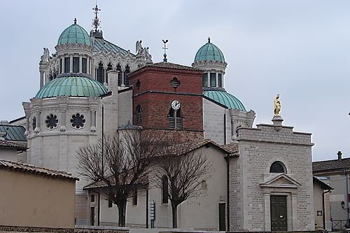
The commune has several religious buildings and structures that are registered as historical monuments:
The commune has a very large number of religious items that are registered as historical objects. For a complete list with descriptions (in French) click here.
