
Canton Lembeye Population 141 (1999) | Area 9.64 km² | |
 | ||
Intercommunality Canton de Lembeye en Vic-Bilh | ||
Arrosès is a French commune in the Pyrénées-Atlantiques department in the Nouvelle-Aquitaine region of south-western France.
Contents
- Map of ArrosC3A8s France
- Geography
- Toponymy
- History
- Administration
- Inter communality
- Demography
- Economy
- Civil heritage
- Religious heritage
- References
Map of Arros%C3%A8s, France
Geography
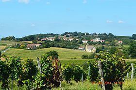
Arrosès is located some 50 km south-east of Hagetmau and some 5 km west of Madiran with the eastern border of the commune being the border between Pyrénées-Atlantiques and Hautes-Pyrénées departments. Access to the commune is by the D219 road from Aurions-Idernes in the west passing through the commune north of the village then continuing east to Madiran as the D66. The D292 comes from Aubous in the north passing through the commune and the village and continuing south to join the D139 south of Crouseilles. The commune is mostly farmland with patches of forest scattered throughout.
The commune is located in the Drainage basin of the Adour with several streams rising in the commune and flowing east to join the Saget which flows north to join the Adour near Saint-Mont and forming most of the eastern border of the commune. The Larcis forms most of the western border of the commune as it flows north to join the Lees.
Toponymy
The commune name in béarnais is Arrosés.
Michel Grosclaude proposed as its etymology the anthroponym Arrosés which was very common in the Pyrenees and the Iberian peninsula and well attested in the Middle Ages.
The following table details the origins of the commune name and other names in the commune.
Sources:
Origins:
History
Paul Raymond noted on page 13 of his 1863 dictionary that in 1385, Arrosès had 31 fires and depended on the bailiwick of Lembeye. There was a Tithe in Arrosès parish called Sainte-Rose.
Administration
List of Successive Mayors
(Not all data is known)
Inter-communality
The commune is part of five inter-communal structures:
Demography
In 2010 the commune had 148 inhabitants. The evolution of the number of inhabitants is known from the population censuses conducted in the commune since 1793. From the 21st century, a census of communes with fewer than 10,000 inhabitants is held every five years, unlike larger towns that have a sample survey every year.
Sources : Ldh/EHESS/Cassini until 1962, INSEE database from 1968 (population without double counting and municipal population from 2006)
Economy
The town is part of the Appellation d'origine contrôlée (AOC) zones of Madiran, Pacherenc-du-vic-bilh, and Béarn AOC.
Civil heritage
A number of structures have been identified as historical monuments. These are:
A Hilarri located at a house in the Bouézou area dates to the 17th century. It came from the old church which is now destroyed.
Religious heritage
The Church of Our Lady of the Assumption partially dates to the 12th century. It contains many items which have been registered. These are: