
Intercommunality Amikuze Area 22.81 km² | Population (2009) 365 | |
 | ||
Beton imprime arraute charritte 64120 france www betonimprimeart fr youtube
Arraute-Charritte (Basque: Arrueta-Sarrikota) is a French commune in the Pyrénées-Atlantiques department in the Nouvelle-Aquitaine region of south-western France.
Contents
- Beton imprime arraute charritte 64120 france www betonimprimeart fr youtube
- Map of 64120 Arraute Charritte France
- Geography
- Toponymy
- History
- Administration
- Inter communality
- Demography
- Distribution of Age Groups
- Economy
- Budget and Taxation
- Civil heritage
- Religious heritage
- Environmental heritage
- Education
- References
Map of 64120 Arraute-Charritte, France
The inhabitants of the commune are known as Arruetar.
Geography
Arraute-Charritte is located in the former province of Lower Navarre some 40 km east by south-east of Bayonne and 15 km north-west of Saint-Palais. Access to the commune is by the D11 road from Bidache in the north passing through the commune east of the village and continuing to Masparraute in the south. Access to the village is by the D246 from Orègue in the west passing the village then south-west to Masparraute. The D313 also passes down the western border of the commune from the D11 south of Bidache and joins the D246 west of the village. The D310 goes east from the D11 north of the village to Bergouey-Viellenave. There are forests in the north-east and north-west of the commune with a band of patchy forest through the centre. The rest of the commune is farmland.
There is a stop in the commune on bus route 870 from Tardets-Sorholus to Bayonne on the Interurban Network of Pyrénées-Atlantiques.
The Bidouze river forms the north-eastern border of the commune with the Ruisseau de Mandeheguy flowing into it there. Numerous other streams rise all over the commune and flow east to the Bidouze. The Ruiusseau de Bordaberry rises in the north of the commune and flows west to join the Apatharena which forms the western border of the commune and continues north to join the Lihoury. Numerous other streams rise in the commune and flow to the Apatharena.
Toponymy
The commune name in basque is Arrueta-Sarrikota.
Jean-Baptiste Orpustan indicated that Charrite came from Sarri-ko-(e)ta meaning "place of small bushes". However, there is no certainty of the origin of the name Arraute.
The following table details the origins of the commune name and other names in the commune.
Sources:
Origins:
History
The commune of Arraute and its village, Charritte-Mixe, were merged on 27 June 1842.
Administration
List of Successive Mayors
(Not all data is known)
Inter-communality
The commune is part of five inter-communal structures:
Demography
In 2009 the commune had 365 inhabitants. The evolution of the number of inhabitants is known from the population censuses conducted in the commune since 1793. From the 21st century, a census of communes with fewer than 10,000 inhabitants is held every five years, unlike larger towns that have a sample survey every year.
Sources : Ldh/EHESS/Cassini until 1962, INSEE database from 1968 (population without double counting and municipal population from 2006)
Distribution of Age Groups
Percentage Distribution of Age Groups in Arraute-Charritte and Charente-Maritime Department in 2009
Sources:
Economy
The town is part of the Appellation d'origine contrôlée (AOC) zone designation of Ossau-iraty.
Budget and Taxation
The local economy is mainly based on agriculture:
Civil heritage
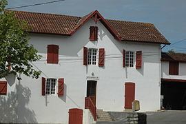
The village is typically Basque and has some Maisons à colombages (timbered houses).
Religious heritage
Environmental heritage
The Banks of the Bidouze are classified as a Natura 2000 site.
Education
Amorots-Succos, Masparraute, Orègue, Béguios, and Arraute-Charritte have created together an inter-communal educational grouping (R.P.I. AMOBA).