
Area 7.56 km² | Population (2009) 102 | |
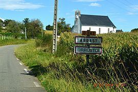 | ||
Arrast-Larrebieu (Basque: Ürrustoi-Larrebille) is a French commune in the Pyrénées-Atlantiques department in the Nouvelle-Aquitaine region of south-western France.
Contents
- Map of 64130 Arrast Larrebieu France
- Geography
- Toponymy
- History
- Administration
- Inter communality
- Demography
- Economy
- Civil heritage
- Religious heritage
- Notable people linked to the commune
- References
Map of 64130 Arrast-Larrebieu, France
The inhabitants of the commune are known as Urrustoitars.
Geography
Arrast-Larrebieu is located in the former province of Soule some 12 km east by south-east of Saint-Palais and 10 km north by north-east of Mauléon-Licharre. Access to the commune is by the D243 road which branches off the D11 west of the commune and north of Espès-Undurein and passes through the village before continuing north-east to join the D115. The D135 from the D11 in the west to Moncayolle-Larrory-Mendibieu in the south-east passes through the south of the commune and the hamlet of Larrebieu. The commune is mainly farmland with many forests scattered throughout the commune.
The Laxubie rises in the south of the commune and flows north past the village gathering many tributaries and joins the Apaure north of the commune. Several small streams rise in the west of the commune and flow west to join the Saison.
Toponymy
The commune name in basque today is Ürrüstoi-Larrabile.
Jean-Baptiste Orpustan indicated that the spelling in Basque Arrast is sometimes given with the determinant Ürrüxtoia meaning "hazel tree grove". He also stated that larrabil means a "rounded moor, squat".
The following table details the origins of the commune name and other names in the commune.
Sources:
Origins:
History
Paul Raymond noted on page 11 of his 1863 dictionary that the commune had a Lay Abbey, vassal of the Viscounts of Soule.
Larrebieu was merged with the commune of Arrast on 16 October 1842.
Administration
List of Successive Mayors
(Not all data is known)
Inter-communality
The commune is part of seven inter-communal structures:
Demography
In 2009 the commune had 102 inhabitants. The evolution of the number of inhabitants is known from the population censuses conducted in the commune since 1793. From the 21st century, a census of communes with fewer than 10,000 inhabitants is held every five years, unlike larger towns that have a sample survey every year.
Sources : Ldh/EHESS/Cassini until 1962, INSEE database from 1968 (population without double counting and municipal population from 2006)
Economy
Economic activity is mainly agricultural (livestock and pasture). The town is part of the Appellation d'origine contrôlée zone designation of Ossau-iraty.
Civil heritage
An enclosure with an earthen parapet (a protohistoric fort or Gaztelu zahar) at an altitude of 282 metres at a place called Gazteluxaga reflects the ancient past of the commune.
Religious heritage
The Parish Church of Sainte-Lucie (19th century) is registered as an historical monument. It has a bell tower called Trinity or Souletin meaning the "top of the wall", pierced by bays for the bells with three roof peaks of approximately equal height, hence the name Trinity. The church contains a Processional Cross (17th century) which is registered as an historical object.