
Area 8 km² | Local time Thursday 12:56 AM | |
 | ||
Name meaning The steppe or plateau of the Buttauf Weather 13°C, Wind W at 2 km/h, 85% Humidity | ||
Arraba (Arabic: عرّابة; Hebrew: עַרָבָּה), also known as 'Arrabat al-Battuf, is the fourth largest local council and largest Arab local council in Israel. It is located in the Lower Galilee in the Northern District, within the Beit Netofa Valley (Sahl al-Battuf) to the north of Nazareth and adjacent to Sakhnin and Deir Hanna. Arraba attained local council status in 1965. In 2015 its population was 24,072.
Contents
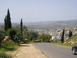
- Map of Arraba Israel
- Economy
- Antiquity
- Middle Ages
- Ottoman period
- British era
- State of Israel
- Notable buildings
- Sports
- Notable people from and residents in the village
- References
Map of Arraba, Israel
Economy
The symbol of the local council is an onion, a watermelon and a cantaloupe which symbolize the crops for which Arraba is famous. Throughout history Arraba was mostly an agricultural village depending mainly on the al-Batuf Plain (Hebrew name: Beit Netofa Valley) to grow crops. However, currently the dependence on agriculture is declining rapidly due to the rise in population, urbanization and a subsequently more modern lifestyle.
Antiquity
Arraba is associated with the Jewish village called Arab, known in Greek as Garaba, mentioned in the Mishnah and the Jerusalem Talmud in the sixteenth chapter of Tractate Shabbat. In the works of Josephus, it is often mentioned by its Greek corruption, Gabara. The famous Jewish Rabbi and scholar, Yohanan ben Zakkai, is said to have lived there eighteen years. During the Jewish war with Rome, Vespasian sacked the city, killing those of its Jewish citizens who had not already fled.
In the 5th or 6th century CE there were Christians living here, as witnessed by a church whose mosaic floor and inscription have been unearthed.
Middle Ages
In the Crusader era, it was known as Arabiam. In 1174 it was one of the casales (villages) given to Phillipe le Rous. In 1236 descendants of Phillipe le Rous confirmed the sale of the fief of Arraba. In 1250 it was one of the casales (villages) belonging to the Teutonic knights, a Crusader order.
In the 13th century Arrabah is mentioned by Syria geographer Yaqut al-Hamawi in his famous work Mu'jam al-Buldān (1224–1228), as a "place in the province of Acca".
Ottoman period
The village was incorporated into the Ottoman Empire in 1517 with all of Palestine, and in 1596 Arraba appeared in the tax registers as being in the Nahiya ("Subdistrict") of Tabariyya of the Liwa ("District") of Safad. It had a population of 125 Muslim households and 2 Muslim bachelors, and paid taxes on wheat, barley, summercrops or fruit trees, cotton, and goats or beehives.
At some point in the mid-17th century the Zayadina, an Arab Muslim tribe, immigrated to Arraba. Its sheikh ("chief") later acquired control of the town and its district after wresting control of the area from the Druze sheikh of Sallama. Sallama and other Druze villages in the vicinity were subsequently destroyed, Druze suzerainty over the Shaghur district came to an end and the Zayadina consequently gained significant influence in the area, including the role of tax collector of Shaghur on behalf of the Ottoman wali ("governor") of Sidon Province. Arraba became home to Zahir al-Umar, a later sheikh of the Zayadina tribe. According to local legend, he sought refuge there after killing a Turkish soldier. He won the support of the local sheikh, Muhammad Nasser, by helping him settle a score with a neighboring village, which set off a series of campaigns that led to the conquest of the entire Galilee. A building said to be the home of Zahir is still standing.
French explorer Victor Guérin visited the village in the 1870s, and found it to have 900 Muslim inhabitants and 100 Greek-Orthodox Christians. In the 1881 the Palestine Exploration Fund's Survey of Western Palestine (SWP), Arrabet al Buttauf was described as "A large stone-built village, containing about 1,000 Moslems and Christians, and surrounded by groves of olives and arable land. Water is obtained from a large birkeh and cisterns. This was the place where Dhaher el Amr´s family was founded, and was long occupied by them."
British era
In the 1922 census of Palestine, conducted by the British Mandate authorities, Arrabeh had a population of 984, 937 Muslim and 47 Christian, of the Christians, 42 were Melkite, 4 Orthodox and one was Anglican. At the time of the 1931 census, Arraba had 253 occupied houses and a population of 1187 Muslims and 37 Christians.
In 1945 the population was 1,800; 1,740 Muslims and 60 Christians, with 30,852 dunams of land, according to an official land and population survey. 3,290 dunams were used for plantations and irrigable land, 14,736 dunams for cereals, while 140 dunams were built-up (urban) land.
State of Israel
In 1948, during Operation Hiram (October 29–31), the town surrendered to the advancing Israeli army. Many of the inhabitants fled but those that remained were not expelled by the Israeli soldiers. The village remained under Martial Law until 1966.
Arraba was home to the first Land Day demonstrations in 1976. Together with Sakhnin and Deir Hanna it forms what is called the triangle of Land Day. Israel's reaction to control the protest was forceful and six people were killed by Israeli police.
On March 11, 1976, the Israeli government published an expropriation plan including lands in the Galilee for official use. It affected some 20,000 dunams of land between the Arab villages of Sakhnin and Arraba. The land was said to be used for security purposes, but was also used to build new Jewish settlements. David McDowall identifies the resumption of land seizures in the Galilee and the acceleration of land expropriations in the West Bank in the mid-1970s as the immediate catalyst for both the Land Day demonstration and similar demonstrations that were taking place contemporaneously in the West Bank. He writes: "Nothing served to bring the two Palestinian communities together politically more than the question of land."
Notable buildings
Andrew Petersen, an archaeologist specializing in Islamic architecture, surveyed the place in 1994, and found several interesting buildings. In the 1870s Guerin saw the mosque which he thought had probably once been a church on the basis of its east-west orientation. Inside there were two monolithic columns which he took as further proof of its antiquity. The present mosque was built In 1953 on the site of the older building. Opposite the mosque is a palatial house. It has an ablaq entrance, made of black and white masonry. This is the house associated with the family of Zahir al-'Umar/Dhaher el-Omar (see photo).
Sports
The town's football club Ahva Arraba, currently play in Liga Leumit, the second tier of Israeli football.