
Intercommunality Iholdi-Ostibarre Area 17.27 km² | Time zone CET (UTC+1) Population 357 (1999) | |
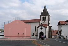 | ||
Armendarits (Basque: Armendaritze) is a French commune in the Pyrénées-Atlantiques department in the Nouvelle-Aquitaine region of south-western France.
Contents
- Map of 64640 Armendarits France
- Geography
- Toponymy
- History
- Administration
- Inter communality
- Demography
- Economy
- Civil Heritage
- Religious Heritage
- Education
- Notable people linked to the commune
- References
Map of 64640 Armendarits, France
The inhabitants of the commune are known as Armendariztar.
Geography
Amendarits is located some 12 km south-west of Saint-Palais and some 8 km north-east of Irissarry and is in the former province of Lower Navarre. Access to the commune is by road D300 from Iholdy in the south to the village. The D8 going east from Iholdy also passes through the southern part of the commune. The D245 from Hélette in the west passes through the commune and the village and continues north to join the D14 just south-east of Méharin. There is also the D408 which links the village to the D8 road inside the commune. Apart from a few patches of forest the commune is entirely farmland.
Numerous streams rise in the commune: the Erreka Handia and its tributaries flows north past the village, the Iharte also flows north to the east of the village, and the Ossinako Erreka forms part of the south-western border as it flows south.
Toponymy
The commune name in Basque is Armendaritze.
The following table details the origins of the commune name and other names in the commune.
Sources:
Origins:
History
Paul Raymond noted on page 10 of his 1863 disctionary that Armendarits was a former Barony, vassal of the Kingdom of Navarre.
Administration
List of Successive Mayors
(Not all data is known)
Inter-communality
Armendarits is part of seven inter-communal structures:
Demography
In 2009 the commune had 381 inhabitants. The evolution of the number of inhabitants is known from the population censuses conducted in the commune since 1793. From the 21st century, a census of communes with fewer than 10,000 inhabitants is held every five years, unlike larger towns that have a sample survey every year.
Sources : Ldh/EHESS/Cassini until 1962, INSEE database from 1968 (population without double counting and municipal population from 2006)
Economy
Economic activity is mainly agricultural. The commune is part of the Appellation d'origine contrôlée (AOC) zone of Ossau-iraty.
Civil Heritage
Several buildings and sites in the commune are registered as historical monuments:
Religious Heritage
Education
The commune has a primary school.