
Length 202 km Source elevation 380 m | Basin size 2,990 km (1,150 sq mi) Discharge 30 m³/s | |
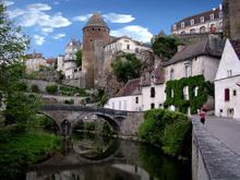 | ||
Main source Bourgogne380 m (1,250 ft) Similar Canal de Bourgogne, Château d'Ancy‑le‑Franc, Tille, Morvan, Fosse Dionne | ||
The River Armançon drains part of north-western Burgundy in France. It rises in the département of Côte-d'Or and flows into the River Yonne (right bank) at Migennes. Its origin is at an elevation of about 380 metres (1,250 ft) above sea level and enters the River Yonne, 202 kilometres (126 mi) downstream, at 79 metres (259 ft).
Contents
Map of L'Arman%C3%A7on, Vergigny, France
Course
It rises 2 kilometres (1.2 mi) north-west of Meilly-sur-Rouvres in the district known as the Auxois, on the lip of the saucer represented by the Paris Basin. It flows down the western, dip slope of the Côte d'Or and on the margin of the Morvan. Its source is on the Lower Jurassic rocks where they and the Upper Triassic are much influenced by the granites and volcanism of the Morvan, a northward extension of the Massif Central.
The river's upper valley is used by the Canal de Bourgogne and the Autoroute A6 but the two diverge and the river passes between them, alone towards the small town of Semur-en-Auxois. In this part of its course the river has cut its valley down through the Jurassic rocks to the underlying granite. The Cernant joins just below Semur.
Near Buffon, north-west of Montbard, the canal joins it again from the Brenne valley accompanied by the Dijon to Paris (Gare de l'Est) railway. The Bornant enters from the left slightly lower. They all pass through forested country on Middle Jurassic geology. Shortly after, they pass into the département of Yonne. Near the border between the départements and just below Ravières, the river passes onto the Upper Jurassic where the valley bottom has accumulated Holocene alluvium. However, the Upper Jurassic rocks are available to supply the clay element of the materials for the cement works which lie between the river and the canal between Pacy-sur-Armançon and Lézinnes. Still in forested country, it passes the small town of Tonnerre and passes very briefly through the département of Aube as it flows onto the lower Cretaceous rocks, clothed in less woodland.
Just below Saint-Florentin it is crossed by the TGV railway from Paris to Lyon and Avignon. The river arrives on the Middle Cretaceous as the Créanton joins from the right, just before the river and the Canal de Bourgogne enter the River Yonne at Migennes. The town is backed by the relatively treeless Upper Cretaceous chalk.
The Lower Cretaceous is comparable with the rocks of the Weald of southern England and the Upper Jurassic with the Oxford Clay and associated strata of the English Midlands. The middle Jurassic rocks contain more limestones. The Upper Cretaceous is mainly chalk
Tributaries
Its principal tributaries are:
Ru is an old or literary word for "brook". Ruisseau is usually translated as stream. It can mean "gutter".