
Existed: 1926 – present Length 150.4 km Major cities Jonesboro, Blytheville | West end: AR 69, Jacksonport Constructed 1926 | |
 | ||
East end: Mississippi River, Tennessee state line Counties Jackson County, Arkansas, Poinsett County, Arkansas, Craighead County, Arkansas, Mississippi County, Arkansas | ||
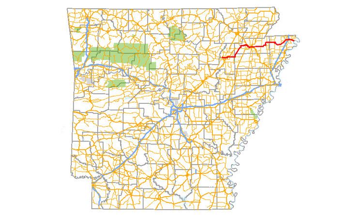
Arkansas Highway 18 is a state highway of 93.43 miles (150.36 km) in Northeastern Arkansas.
Contents
Map of AR-18, Arkansas, USA
Route description
AR 18 begins at AR 69 near Jacksonport. Brief concurrencies begins with AR 17 and US 67 in Newport, and Arkansas Highway 18S leads to Newport Municipal Airport as AR 18 continues east. The route runs east to AR 37 in Grubbs before turning north at Uno to AR 226 in Cash. AR 18 joins AR 91 and becomes King's Highway.
AR 18/AR 91 run together with US 63 into Jonesboro. AR 18 breaks and runs as Highland Dr., meeting US 49/AR 1. After Jonesboro, AR 18 meets AR 158 and AR 135 in Lake City. The three routes continue east to Black Oak, when AR 18 turns north. AR 18 briefly runs with AR 139 in Monette before continuing east. AR 18B is created in Manila, and AR 18 meets AR 77.
The route briefly meets AR 181 near Dell before turning northeast to Blytheville. AR 18 meets AR 151 and US 61 in downtown Blytheville. The route continues east to cross over Interstate 55 (exit 67) in a frontage road interchange. AR 18 and AR 312 meet briefly south of the Blytheville Municipal Airport. The route continues to terminate at the Mississippi River at the Tennessee state line.