
Length 2.66 km | ||
 | ||
Existed: 2008 (Current Routing) – present County Washington County, Arkansas | ||
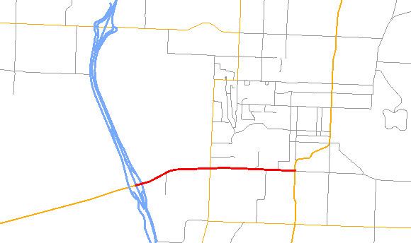
Highway 180 (AR 180, Ark. 180, Hwy. 180, also officially Martin Luther King Jr. Boulevard) is a state highway of 1.65 miles (2.66 km) in Fayetteville. The route begins at Interstate 49/US 62/US 71/Highway 16 and runs east through Fayetteville to US 71 Business. Highway 180 is designated as part of the Trail of Tears National Historic Trail as well as Arkansas Heritage Trails designations as the Butterfield Trail, Trail of Tears (Benge Route), and Civil War Trails (Herron's Approach).
Contents
Map of AR-180, Fayetteville, AR, USA
Route description
Highway 180 begins at US 62 just underneath the Interstate 49/US 62/US 71/AR 16 overpass in western Fayetteville. It continues east with Highway 16 until a junction with Highway 112, when Highway 16 turns south with Highway 112. Highway 180 continues east past the University of Arkansas, Fayetteville High School, and the Fayetteville National Cemetery to terminate at US 71B (South School Avenue). The roadway continues east as Dr Martin Luther King Jr Drive. The route is entirely four lane, with a center left-turn lane.
History
As early as 1930, the road was named Wall Street in the city limits of Fayetteville. The road later became 6th Street. Between 1971 and 1989 this road was designated US 62 Business.
On January 15, 2009, Fayetteville renamed Sixth Street to Martin Luther King Jr. Boulevard. The ceremony took place at the Razorback Road intersection at the entrance to the University of Arkansas. Most Fayetteville businesses on the road still claim 6th Street, and many residents and university students continue to call the road 6th Street over two years after the change.
Major intersections
The entire route is in Fayetteville, Washington County.
Former routes
Arkansas Highway 180 was a state highway of 1.5 miles (2.4 km) in Fayetteville. Its original location was along Assembly Road and Skyline Drive where it circled around Mount Sequoyah and returned to its single terminus of Highway 45. This segment was dropped from the state highway system in the early 1990s.
Arkansas Highway 180 was a state highway of 1.8 miles (2.9 km) in Fayetteville. The route began at U.S. Route 71 Business in Fayetteville and followed Township Road, Gregg Ave and Drake Street before ending at AR 112. In the 1990s this segment was extended north along Gregg Ave and ended at a spur of U.S. 71 Business on the north end of Fayetteville. This segment was dropped from the state highway system in 2008 following the widening of Gregg Ave.