
Existed: 1930 – present Constructed 1930 | Length 190.1 km | |
 | ||
Rob trudell drives arizona state route 86 highway east to sells az 10 august 2014 gp017767
State Route 86 (or SR 86) is a state highway in southern Arizona that stretches from its junction with State Route 85 in Why east to its junction at 16th Avenue east of Interstate 19 in Tucson. It formerly went east to the New Mexico border near Lordsburg, but this eastern segment has been superseded by Interstate 10. SR 86 is the primary east–west highway through the Tohono O'odham Nation. Note that this route is commonly blocked off by US Department of Homeland Security Border Patrol Agents to perform random searches of vehicles, due to its proximity to the Mexico border.
Contents
- Rob trudell drives arizona state route 86 highway east to sells az 10 august 2014 gp017767
- Map of AZ 86 Arizona USA
- Route description
- History
- Junction list
- References
Map of AZ-86, Arizona, USA
Route description
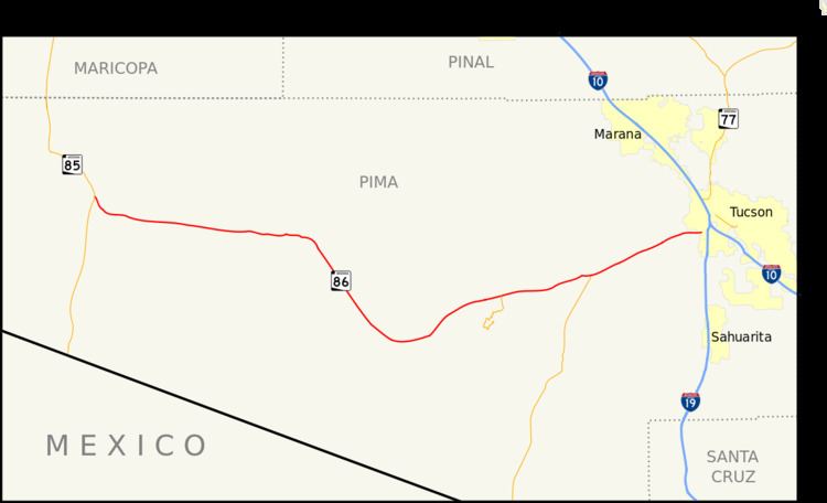
The western terminus of SR 86 is located at a junction with SR 85 in Why. From this intersection, the highway heads southeast, but curves towards the east as it enters the Papago Indian Reservation. It continues towards the east passing through the communities of Schuchuli, Gunsight, Wahak Hotrontk, Plato Vaya, Covered Wells before curving towards the southeast near Quijotoa. It continues southeast until curves towards the east in Sells. It curves towards the northeast near Little Tucson and curves back to the east near San Pedro. The highway curves towards the northeast just prior to leaving the reservation. SR 86 curves towards the east as it enters Tucson. In Tucson, the highway continues east past an interchange with I-19 to 16th Avenue, which serves as its eastern terminus.
History
SR 86 was originally designated in 1930, between Willcox and Bowie. In 1931, it was extended west to Benson and east to the New Mexico state line, effectively serving as a direct bypass to the US 80 Douglas loop. From 1927 to 1960, the remainder of the bypass between the Arizona border and Road Forks, New Mexico was served by New Mexico State Road 14. SR 86 was further extended through Tucson and the Tohono O'odham Indian Reservation to Ajo in 1943. SR 85 was extended south from Ajo to Lukeville in 1955, establishing a concurrency with SR 86 to Why. In 1970, SR 86 had its eastern end truncated to US 89 (later I-19 Business) in Tucson after being replaced by I-10 between Tucson and New Mexico. In 1991, the concurrency with SR 85 between Ajo and Why was removed, truncating the western end of SR 86 to Why. In 2003, I-19 Business was removed, truncating the eastern end of SR 86 to 16th Avenue east of I-19.
The Census Designated Place of Why was named after the "Y" shaped intersection between SR 85 and SR 86. The intersection has since been rebuilt into a "T" shaped intersection.
Junction list
The entire route is in Pima County.