
Existed: 1990 – present Counties: Maricopa Constructed 1990 | Length 92.01 km | |
 | ||
CW end: Pecos Road in Ahwatukee | ||
Making the turn from gilbert road to arizona state route 202 loop red mountain freeway gopr0102
State Route 202, or Loop 202, (spoken as two-oh-two) is a partial beltway looping around the eastern Phoenix metropolitan area of central Arizona. It traverses the eastern end of the city of Phoenix, in addition to Tempe, Mesa, Chandler, and Gilbert, making it very vital to the metropolitan area freeway system.
Contents
- Making the turn from gilbert road to arizona state route 202 loop red mountain freeway gopr0102
- Map of AZ 202 Mesa AZ USA
- Route description
- Red Mountain Freeway
- Santan Freeway
- History
- Future
- Exit list
- Spur route
- Major intersections
- References
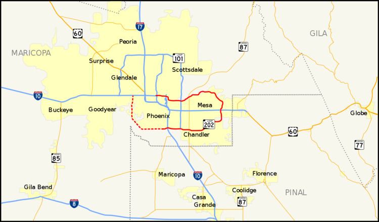
Map of AZ-202, Mesa, AZ, USA
Loop 202 has various names along its route:
Route description
The route currently begins at the Mini Stack interchange with Interstate 10 (I-10) and State Route 51 (SR 51) in Phoenix, and ends at I-10 near Ahwatukee.
Loop 202 consists of three sections. Two of these, the Red Mountain Freeway and the Santan Freeway, have been fully completed. The third section, known as the South Mountain Freeway, is under construction.
Red Mountain Freeway
The first section of Loop 202 to open was the Red Mountain Freeway. It runs from the I-10/SR 51 Mini Stack interchange to US 60. It passes over the Salt River and through Tempe and Mesa en route, with an interchange with Loop 101 in Tempe. The final segment of the freeway from Power Road to University Drive opened on July 21, 2008. This opening marked the completion of the original Regional Freeway System as approved by Maricopa County voters in 1985 by Proposition 300.
In 2006, this portion of Loop 202 was used to portray a Saudi Arabian superhighway in the 2007 film, The Kingdom. Filming also took place at Phoenix-Mesa Gateway Airport and the Arizona State University Polytechnic Campus. The city of Mesa received $40,000 for the use of the freeway from NBC Universal.
As of October 2012, HOV lanes on the Red Mountain section run from I-10/SR 51 to Gilbert Road. In 2015, the HOV lanes were extended from Gilbert Road to Broadway Road. HOV lanes are planned to extend to US 60 in Mesa, eventually tying into planned HOV lanes on the Santan Freeway.
Santan Freeway
Completed in 2006, the Santan Freeway serves the southeast valley cities of Chandler, Gilbert, and Mesa. It provides access to Phoenix-Mesa Gateway Airport, the former Williams Air Force Base. Beginning at the SuperRedTan Interchange with US 60 in Mesa, the freeway runs south and turns westward in Gilbert near the airport. A few miles later the Santan is running in Chandler, where it has a junction with Loop 101 in the vicinity of the Chandler Fashion Center. Following this interchange, the Santan Freeway section of Loop 202 encounters its terminus at a stack interchange with I-10 near Ahwatukee.
The Santan section has HOV lanes between I-10/Pecos Rd. and Gilbert Rd. Long term plans call for HOV lanes to extend to US 60 and to the HOV lanes on the Red Mountain section.
History
The highway originally was assigned many different route numbers along its path. The portion of the Red Mountain Freeway west of the Pima/Price Freeways was formerly known as the "East Papago Freeway," and it was initially designated SR 217. The remainder of the Red Mountain Fwy. was to be SR 216. The San Tan Freeway was originally routed as SR 220. The South Mountain Freeway portion was initially supposed to be SR 218. The Loop 202 designation was first assigned in 1987, along the East Papago and Red Mountain Freeway corridors and the portion of the San Tan Freeway east of Price Road. At that time, the portion of Loop 202 west of Price Rd. was to become part of Loop 101. But in 1991, the proposed South Mountain Freeway was renumbered as part of Loop 202. Although the San Tan Freeway portion of Loop 101, from I-10 to Price Rd., has never officially been renumbered, this section has been signed as Loop 202 since its opening.
Future
The third segment of Loop 202, named the South Mountain Freeway, received final approval from the Federal Highway Administration, on March 10, 2015, with construction scheduled for completion as early as 2019.
Before that it was, and remains, the most controversial segment of the Loop 202 partial beltway. Construction was delayed due to tension between three groups: regional transportation planners, who insisted that the freeway is necessary to ensure smooth traffic flow in the coming decades; residents of the adjacent Ahwatukee community, who could lose 120 homes to eminent domain depending on the road's final alignment; and leaders and residents of the adjoining Gila River Indian Community (GRIC), who have oscillated between opposing and supporting the freeway in recent years.
The South Mountain Freeway has two distinct segments: the "eastern segment" that straddles the Ahwatukee-GRIC border and the "western segment" that will parallel 59th Avenue through the southwest Phoenix community of Laveen. Together, these segments would form a 21.9-mile bypass around Downtown Phoenix, linking the metropolitan area's southwestern and southeastern suburbs. The freeway as currently approved would begin at the existing four-level symmetrical stack interchange between I-10 and the Santan Freeway on the Chandler-Ahwatukee border and terminate at I-10 and 59th Avenue west of Downtown Phoenix.
The specific alignment of the freeway has been revised repeatedly since 1985, when Maricopa County voters originally approved its construction as part of the regional highway network envisioned under Proposition 300. In 1988, the Maricopa Association of Governments (MAG), the region's transportation planning agency, suggested an alignment of the freeway's western segment along 55th Avenue and an alignment of the eastern segment along Pecos Road. A federal study in 2001 required ADOT to reexamine those suggestions, and the task of recommending the final alignment fell to a Citizen's Advisory Team formed in 2002. In April 2006, that panel released their final recommendations to route the western portion of the freeway four miles further west to connect with Loop 101, and to reject the proposed alignment of the eastern portion along Pecos Road, suggesting that the latter be built on Gila River Indian Community land instead. Two months later, ADOT overruled the panel's suggestion for the western segment and opted for the current 59th Avenue alignment instead.
In February 2012, a non-binding referendum was held in the Gila River Indian Community on whether the eastern portion of the freeway should be built on community land several miles south of Pecos Road. Options in the referendum were to build on community land, off community land, or not at all. The "no build" option won a plurality of votes, receiving 720 votes out of a total 1,481 cast. MAG sent out a press release soon after making it clear that construction of the freeway would move forward as planned along the Pecos Road alignment. Expecting this outcome, MAG and ADOT had previously (in 2010) shrunk the freeway's footprint from 10 lanes to eight to minimize its impact on Ahwatukee. Fearing the worst possible outcome of the freeway being built without exits onto community land (as would be the case with the Pecos Road alignment), Gila River Indian Community residents quickly formulated plans for a new referendum that would exclude the "no build" option, leaving only "yes on Gila River or no on Gila River." The tribal government rejected this proposal in July 2013.
As late as September 2013, the freeway still faced active opposition. A non-profit group called the Gila River Alliance for a Clean Environment filed a civil-rights complaint with ADOT in July, claiming the freeway would disproportionately and adversely affect tribe members. A freeway opposition group called Protecting Arizona's Resources and Children planned an environmental lawsuit. And the Environmental Protection Agency in August 2013 raised several objections to the state's 12-year, $21 million draft environmental impact statement that had deemed construction of the freeway to be more beneficial to the environment, by improving traffic flow and thus reducing pollution, than building no freeway at all. The EPA claimed that the statement contained overly optimistic traffic projections, did not sufficiently address air quality concerns, and could harm neighboring communities and environmental resources.
In March 2015, the Federal Highway Administration (FHWA) issued a Record of Decision approving the project and selecting a build alternative. ADOT immediately thereafter commenced right-of-way acquisition and the procurement of final design and construction services in the form of a design-build-maintain contractor or "developer." The developer will be selected at the end of 2015 and freeway construction will begin in early 2016, with the Chandler Boulevard extension project to facilitate local access beginning in summer 2015. The freeway is planned to be open to traffic in late 2019 or early 2020. However, new lawsuits in June 2015 from the group Protecting Arizona's Resources and Children, the Sierra Club, and the Gila River Indian Community threaten to delay the freeway's construction.
On August 26, 2015, ADOT started demolition of the first houses along the route for the South Mountain Freeway.
On February 27, 2016, the contract to design, build, and maintain the freeway was awarded to Connect 202 Partners, a joint venture led by Fluor Corporation, with Fluor, Granite Construction, Ames Construction, and Parsons Brinckerhoff being responsible for the final design and construction, and with Fluor and DBi Services, LLC being responsible for maintenance for 30 years.
A six-mile stretch of the freeway, from 40th St to 17th Ave, will include a 16 foot wide bike path. The path will be on the south side of the freeway and will also be open to pedestrians. The path was included because the existing roadway had been a popular cycling route for years.
The first phase of construction of the South Mountain Freeway segment of Loop 202 began on September 19, 2016 with improvements to the I-10/Loop 202 Santan interchange.
Exit list
Exit numbers of the South Mountain Freeway portion are approximate. The entire route is in Maricopa County.
Spur route
Arizona Spur 202 is an unsigned state highway located in Phoenix. It begins at the Red Mountain Freeway (Loop 202) at exit 5. It continues west, intersecting the Hohokam Expressway (SR 143) and ends at Phoenix Sky Harbor International Airport. This is an unsigned route, marked by westbound exit signs from Loop 202 as Sky Harbor Boulevard. The spur route was commissioned in 1993.
Major intersections
The entire route is in Maricopa County. All exits are unnumbered.